Wednesday, July 31, 2013

Bears Go East: Newfoundland

The following events happened on July 8, 2013
We have reached the most eastern (and northern point for that matter) of our epic road trip east: Corner Brook Newfoundland.

We (my wife, two kids, and Yours Truly) are in the middle of an epic road trip to explore the eastern seaboard of North America, from North Carolina to Newfoundland.

We have essentially one day to explore, and since it is not exactly an easy place to get to (due to distance and an inconvenient ocean), we wanted to make the most of it.

We got some tips and ideas of things to do from locals on the ferry yesterday, but a lot of them required more time than we had.   My wife is not a geocacher, and I didn't want to dominate the day finding tupperware - I wanted her to do stuff she wanted to do, but we had no idea what.

I, of course, am a geocacher, and I happened to have a list of highly favourited geocaches loaded up, so I suggested that we at least start the day by going to a geocache that promised a nice view of the bay. This turned out to be the best decision we could make.  Having this list of top caches quickly turned the day from a series of "I dunno, what do *you* wanna do?", to awesome exploration bliss.

We started the day by grabbing drive-thru breakfast(this hotel being the only one we've stayed at this trip that hasn't served breakfast), then headed up the hills to GZ.

After feasting on McBeakfastMeats at a picnic table, we checked out the views.  The cache (actually two caches, but who's counting?) was at a park that held a monument to Captain Cook, the explorer who mapped most of the Newfoundland coast in the 1760s.  It seemed a fitting start to a day of exploration to visit the monument of exploration history.

Oh, about those views... this was the view from the park:
This cache worked out so well (I got a smiley, we all got awesome things to look at), we came up with a plan of caching the best of caches in the city, then going for a drive out along the bay when the kids go for a nap in the van after lunch.

Our next stop was a cache at a train museum.  When we arrived Abigail fell asleep in the van, so my wife stayed behind while Zeke and I explored two trains ($2 for a year pass - not shabby!).  We also found the cache, which was hidden 500ft down a set of old tracks.
Our next step was to take that scenic drive along the bay about 40 klicks east to Blow Me Down Provincial Park (that is the real name, I swears it!).   It was here we came across an amazingly beautiful scene.  A beach, clear blue water of the bay, and tall hills outlining the whole thing.

We let the kids play in the water before eating a picnic lunch.  You can see some of the bay in the backgrounds, and baby smiles in the fore.
The beach was all nice smooth rocks, so little sand to get into diapers.  The kids had a blast playing, and I spent some time skipping stones.
The possibilities of play seemed endless, but soon it was time to eat lunch and do some exploring.  
After lunch we walked 700ft down the beach to grab a cache.  It was hidden among these large rocks.  It was a bit of a climb over them, but I managed to make the grab without breaking and legs, or scraping any skin.
We then went on a hike up the mountain that formed the coastline along the eastern side of the beach.  It is about a 750ft climb - fortunately they built wooden deck and stairs to make it easier.  At the top is an observation platform, and a geocache (in theory).  I was unable to find this cache - my first DNF of the trip actually - but when faced with views like this, it hardly seems to matter.
On the way back down from the observation deck I took a detour to log an earth cache at the base of the Governors Staircase, which is a set of wooden stairs set in the cleft of a rocky cliff that runs from the beach up 50ft or so.  I had Abigail on my back (in a baby sling my wife made - forgive the girliness of it - maybe the next one she makes will be in manly camo)


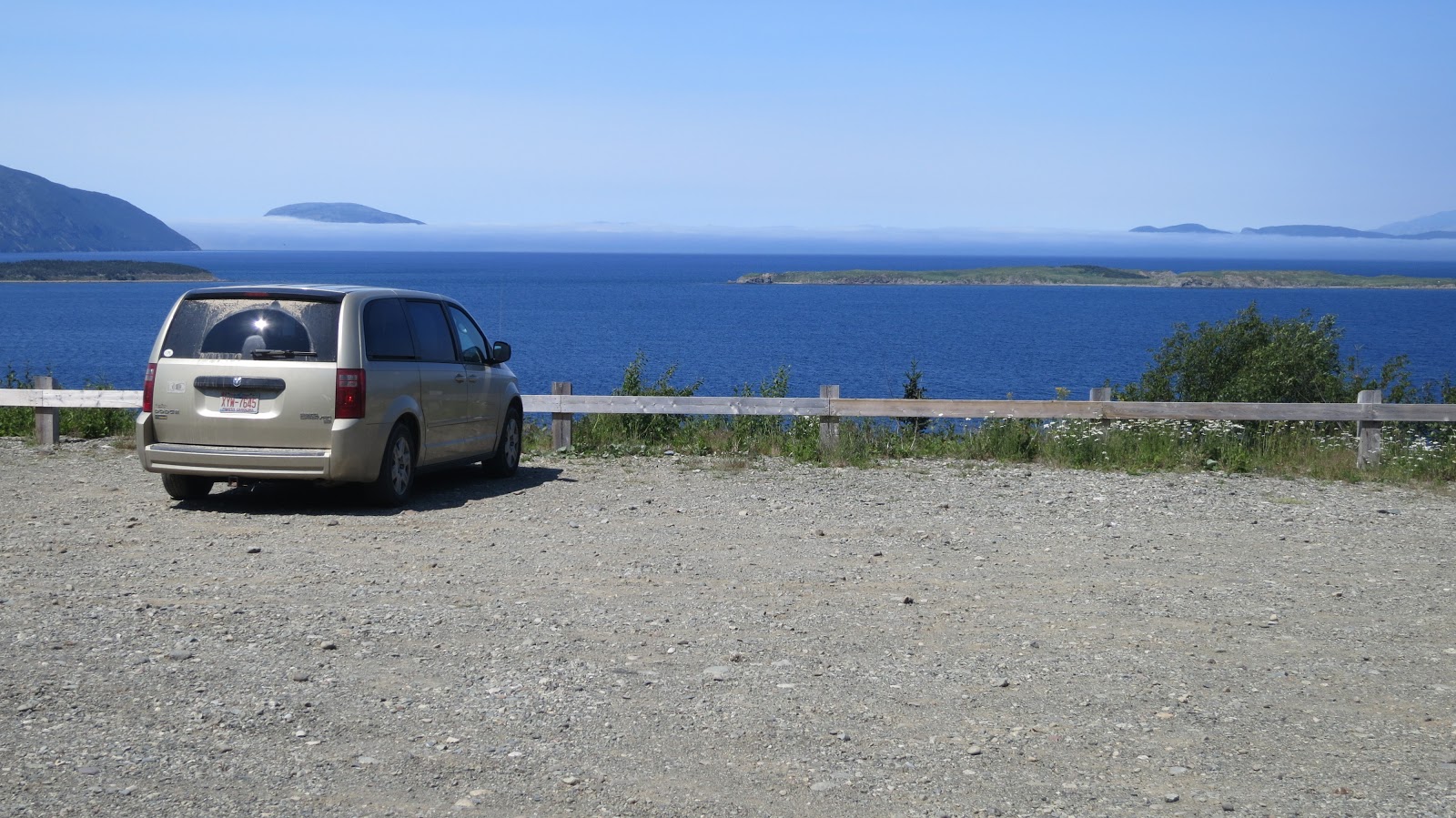
On the way back to Corner Brook we stopped by an old copper mine.   There was a cache at the (unfortunately) blocked off mine entrance.  There is another cache a half klick down the trail, which was an easy find... once I found the right trail. There are two trails that lead from the parking lot... one goes up, one goes down.  I of course took the one that went up, and didn't realize my mistake until I was 300ft up, and 600ft down the trail. I then did a retrograde maneuver and located the correct trail (in my defense the trail map only shows one trail, and the trail head for the other trail is hidden by some trees).  This was the view from GZ...

... and this is the view from the parking lot.    I can take this view all day long.
After this we drove around some more, and saw a crackin' good totem pole, and some more amazing scenery.  Then we headed back to the hotel to get some food and rest.  Tomorrow we head back across the ferry to Nova Scotia.

We're about half way done, but we are not yet finished exploring Canada, so stay tuned to see where we end up next.

Tuesday, July 30, 2013

Bears Go East: Newfoundland Ferry

The following events happened on July 7, 2013
I, along with my family, are on an epic road trip east. Our ultimate goal is to visit the bonny island of Newfoundland, but we are visiting many points in between.

Today's adventures brought us over land and sea. Literally.  For today we take the ferry crossing from the mainland in North Sydney Nova Scotia, to Corner Brook Newfoundland (via Port Aux Basques).

It was a long, but relatively uneventful trip. Our ship was scheduled to sail at 9am, but we had to check in 2 hours ahead of time. Why this is I am not entirely sure - (it certainly wasn't for security as  the only security check was a cursory examination of my drivers license to ensure I was the person that booked the ticket), I suspect its parking planning and ship balancing.

The crossing itself took about 6 hours.  On board the ferry, which was named the Blue Puttees (for the Canadian regiment sent to fight in World War I), there are lots of amenities - restaurants, play areas, and observation decks.  We booked a cabin so the kids could nap.

Getting on the ferry was relatively easy - especially considering the fact that my wife was driving, so I just had to sit and observe. There are 4 parking decks.  According to a deck hand the ship can accomodate up to 500 cars. We were parked on deck 1, in the very bottom of the ship.

Aside from the plethora of windows, there are outside decks where one can get a view from the sides and back of the boat - there isn't a way I could find to get an outside view from the bow.  This is the port we left: North Sydney harbour.


The back of the ship, showing all the water churned up from the propellors.

During the crossing a lot of marine wildlife can be observed.  I saw a lot of sea birds, and several pods of dolphins, like these guys.

Since I had never been to Newfoundland before, my first order of business was to find a cache to mark the occaision.  The cache I picked had these characters painted up.  For scale, these are 7ft high cement balls.  This one seemed to be saying "welcome to Newfoundland, eh?"

From the ferry terminal at Port Aux Basques we still had a 2.5 hour drive to Corner Brook where we would be staying the night.  We arrived at 7pm local time, completely exhausted.  We grabbed a quick bite to eat, put the kids to bed, and collapsed.

Tomorrow we can start exploring Newfoundland.  I wonder what we'll see... stay tuned!

Monday, July 29, 2013

Bears Go East: Cape Breton

The following events happened on July 6th, 2013

I, along with my wife and two kids, are on an epic road trip.  Our goal is to get to the bonny isle of Newfoundland, and see as many points in between as we can.

We started the day in Halifax NS, and our destination was to get to the far northern coast of Nova Scotia so we could catch the ferry to Newfoundland early the next morning.

This was mainly a driving day so we didn't get a lot of super awesome exciting adventures in, tho we did manage to eat a McLobster, and find some fun geocaches.

We also crossed the 45th parallel, which is the line that is equidistant between the north pole and the equator.

Much of the drive today was dominated by beautiful scenery.  Nova Scotia, and especially Cape Breton Island, has a lot of lakes, rivers, and shorelines to add a lot of visual interest.


The Canso Causeway is a thin thread of roadway that connects Cape Breton Island to the north with the mainland to the south.  It was about half way through our trip. There is a geocache in the hills on the north shore, which is where I took this shot from.
Along the way we decided to do a geocache called Cape Breton Oddities: Swamp People.  Despite the cache being a mile from the main highway, we ended up driving along an old dirt road for 22 KMs.  The name of the road was Loch Lamond Road, so we got to sing the old scottish song:
"Oh, ye'll tak' the high road, and I'll tak' the low road,
And I'll be in Scotland afore ye;
But me and my true love will never meet again
On the bonnie, bonnie banks o' Loch Lomond."

We also saw some evidence of logging activities...
... and of course, swamp people.
The road was dry and dusty, so the van was covered in a thick layer of dust by the time were were finished.

We are spending the night in Sydney Nova Scotia, and heading out early (wake up: 5:30AM) to catch the ferry to Newfoundland.  I can't wait!  I wonder if we'll make it on time...

Sunday, July 28, 2013

Bears Go East: Halifax

The following events happened on July 5th, 2013

I am on an epic road trip with my family.  Our ultimate destination is to visit the bonny isle of Newfoundland.  Along the way we are exploring the world and getting into adventures.

Today we are in Halifax, Nova Scotia.  We hit up most of our planned activities for today yesterday, so we didn't really have anything on the schedule for today, so we decided to do some freestyle exploring. My wife saw ads for a people ferry, which we figured the kids would like, so we headed downtown to see what adventures we could get into.

When we got downtown we found a tour boat that would take us out in the harbour on a sailing ship.  So we decided that was better than a ferry and signed up immediately. The following are some shots from the boat, starting with Abigail looking in the porthole to the galley below.


 Out on the water is a great way to see the skyline of Halifax.

 This is a panorama shot taken by holding my cell phone off the side of the ship for a minute or so.

After lunch (consisting of ice cream and poutine, cause: vacation), we headed to the southern tip of Halifax to Pleasant Point Park where the kids did some beach playing, and I did some geocaching.

The park was an old fortress back in the day when Canada needed defending from such scallywags as the French, and the Americans (note: we settled the second one a few years later).  This is an old tower that was used for harbour defense.


After the park we headed back to the hotel for some food, a swim, and to get some rest.  Tomorrow we're going to head north to Sydney Nova Scotia.  I wonder what trouble we will get into then?


 With this crew in tow, one never knows.

Saturday, July 27, 2013

Bears Go East: Peggy's Cove

The following events happened on July 4th, 2013
I am on an epic road trip with my wife and two kids.  Our destination is the bonny island of Newfoundland, and many points in between.

This morning we woke up to find that the rain had disappeared and the prospects for a bright sunny day were upon us.

We had planned on visiting the Bay of Fundy, but due to a bit of fortuitous re-scheduling of our plans we did that yesterday.

Since we had some extra time to kill we decided to do tomorrow mornings plans this afternoon.  So we hopped into the Geovan of Destiny and rushed over (by rushed I mean we only found 4 geocaches along the way), and got down to business.

The first order of business was to find Canada's first geocache.  I covered this earlier so I won't rehash it here.  Needless to say it was cool to put my name in the logbook of such a historic cache.

We then headed over to the historic and picturesque Peggy's Cove.

Our first stop was the memorial to Swissair Flight 111, which was an plane that crashed in the ocean near Peggy's Cove in 1998. 229 people died in that tragic accident.


It is a touching memorial, but it also provides some amazing views of the Atlantic ocean, and Peggy's Cove itself.

 We then headed over to Peggy's Cove proper, which is an active fishing village, as well as a tourist destination. It is a quaint little town that one (at least I) imagine when one thinks of a "small Nova Scotia village".
 Of course the main draw for tourists to Peggy's Cove is the famous lighthouse.
 After we "did the cove" we headed over to the hotel in Halifax for some kid bathing, and resting.  Tomorrow we'll venture downtown to see what adventures we can get into.  What will that be?  I dunno yet - we're gonna wing it.  Stay tuned for how well we managed!

Friday, July 26, 2013

Bears Go East: Fun(dy)!

The following events happened on July 3rd, 2013
I am currently in the middle of a 3 week road trip to explore the north east of North America. We are driving from our home in North Carolina to the bonny isle of Newfoundland, and back.  Along the way we are packing in as much adventure as a carload of toddlers and infants can manage.

This morning we left the hotel just outside Bangor Maine and headed north across the border to our native homeland of Canada.

We grabbed a cache and explored a scenic lake in Maine before making the uneventful crossing into New Brunswick.

I had planned to geocache our way to our destination, but half way through the day we changed plans. As a result we were able to visit a wonder of nature we were not going to be able to otherwise (It did mean I got fewer geocaches today, but geocaching is about the adventure, not the numbers, and as you will see, the adventure was worth it).
These boats only sail at high tide, apparently.

We also ended up with an unexpected theme for the day - The Bay Of Fundy, and its natural wonders.

As you may be aware, the Bay of Fundy sits between New Brunswick and Nova Scotia, and it boasts the highest tide range in the world - 50ft on average.  As a result it has some rather interesting geological attributes.

The first we encountered during our day is the Reversing Falls in Saint John NB.  The name of the falls is not metaphorical.  Like most rivers, it generally flows from the land towards the sea. This is simply due to the fact that the land it at a higher elevation than the oceans are.  When the tides in the Bay of Fundy start to rise, the sea level rises above the level of the river.  At this point the water reverses direction and starts flowing up river.

The Reversing Falls can be seen in the background here.  Currently the water is flowing out to the bay.
 The next stop was the flower pots at Hopewell Rocks.  The flower pots are a series of tall water-carved rocks that were formed by tidal erosion.  During low tide one can walk on the floor of the bay, and check out these tall monuments first hand.  Originally we were going to visit these tomorrow when the tide was high, however we realized we could make it for low tide today, which was what prompted the change of course and a most excellent addition to our adventure.

As you can see the flower pots extend a very long way along the edge of the bay. There is an earthcache that can be found down here.  Walking on the ocean floor *and* a smiley?  Yes please.

The second Zeke hit the bottom he had one goal:  to throw a rock into the ocean.  I am happy to report that a few minutes later he achieved this noble and monumental goal.

The bottom is a mix of rock and mud.  Zeke found some of the muddy spots and got his shoes covered.  I won't tell mommy if you don't.

The final Bay of Fundy related wonder of nature is something called a tidal bore, or really its a mini tsunami.   When the water rises in the Bay of Fundy, the tidal surge pushes a wave, which can be up to 2ft tall, up the Petitcodiac river.  As the tidal bore comes in the direction of the river changes from flowing down stream to up stream, and the water level can rise 7 metres in just over an hour.

The Petitcodaic river runs right past our hotel, and it was scheduled to pass at 7:39pm (with a 20 minute variance on either side).  So once we checked in, we ordered in some food, sat on the patio along the river, and waited.  The tidal bore is also an earth cache.  It was the easiest earth cache I have ever logged.  I didn't even have to move from my table.

This is the view of the hotel from about 0.2 miles down stream.  As you can see the water is rising, and turning blue.

So we are spending the night in Moncton NB. We have already accomplished our planned activity for tomorrow morning, so we should have an easy drive to our next destination. Where is that going to be? Stay tuned!

Thursday, July 25, 2013

Bears Go East: Mapping New England

The following events happened on July 2nd, 2013
I am currently on an epic road trip with my wife and kids. Our ultimate destination is to visit the bonny isle of Newfoundland. Along the way we are taking in as much adventure as we can fit in.

Today we left our hotel in West Warwick Rhode Island and headed north.

There was a lot of rain today, and we had to put in a fair amount of mileage, so we didn't do a lot of extraneous geocaching, but we did manage to get in some rather notable caches just the same.

The highlight was a visit to the map company Delorme.  You may recall that yesterday I blogged about completed the Rhode Island Delorme Challenge - this is the company that inspired those challenges.

Their headquarters is just north of Portland Maine.  In their lobby is a huge (by huge I mean *HUGE* - 3+ stories of pure globe goodness).  It is also a virtual.

 In fact there are 4 geocaching on the Delorme campus - a virtual, another cache inside the building in the form of a geocoin treasure chest, and two relatively easy caches out on the grounds.  I, with the help of my family, found them all. We also toured the on-site store to pick up a map of the earth for the kids, and a globe for us.

This is the bear from "Bears in the bushes" at the Delorme headquarters.  Seemed fitting for a couple of bears to find this cache, eh?

While doing the DeLORME challenge yesterday brdad suggested we do a virtual cache just outside of Boston Mass.  It is a tower located in a cemetery, at the top of a hill.  The views from the top were spectacular:


We ended our day in a hotel in Bangor Maine.  We will be heading back here to spend more time, so today we satisfied ourself with a good meal, and a good nights sleep.

Tomorrow we attempt to cross the border into Canada. I bet you are excited to find out what happens next - the possibilities are endless: Will we get stripped searched by Mounties? Will we "go native" and apologize for no reason?  Will we fatten ourselves at the first Tim Hortons we see and refuse to leave?

Stay tuned!  This adventure has only just begun.