Showing posts with label Hiking. Show all posts

Sunday, February 05, 2023

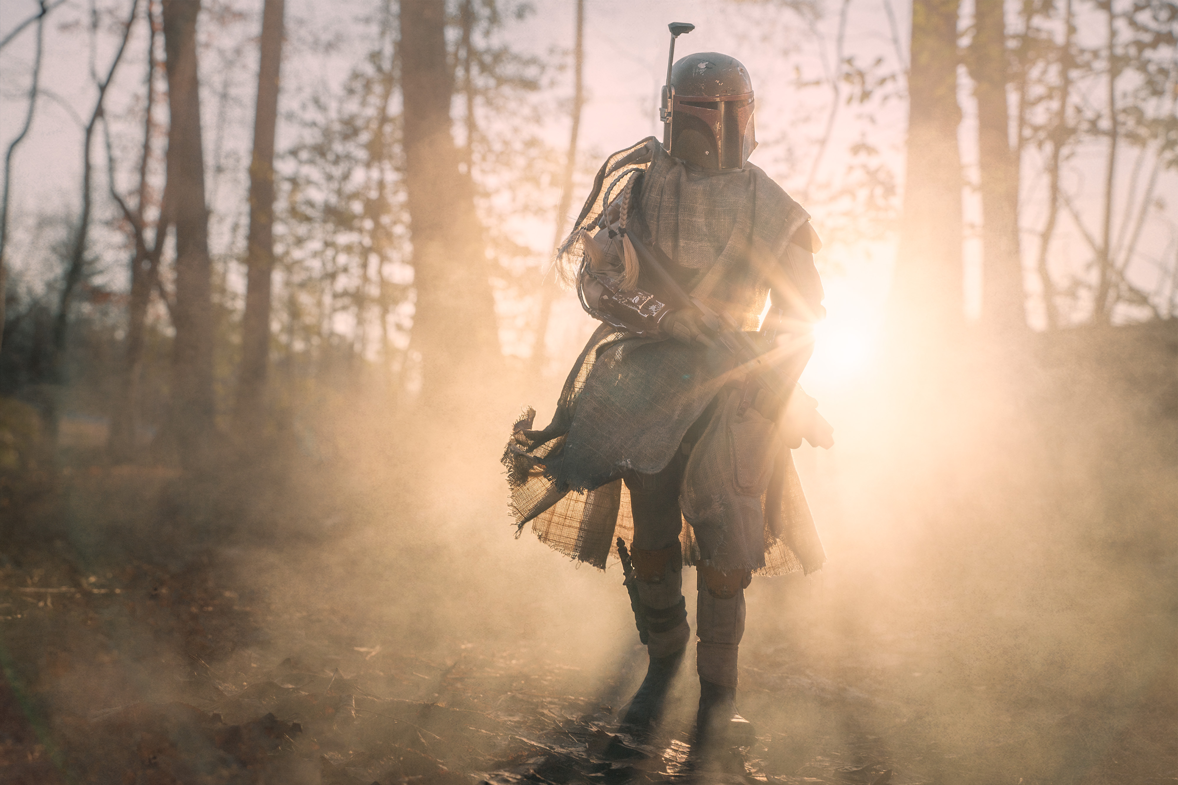
Boba Fett In The Mist

It is funny how inspiration strikes when you're not looking for it.


Took this yesterday on my local walking trail. I've walked that trail several dozen times now. When I walk it in the morning the rising sun shines through the trees. I've taken a few janky videos of it, but nothing serious. I never walk the trail with my camera bag, so I just use my cell phone most of the time.

I love walking it in freezing temps - it hardens up the mud, and I love wearing a hoodie with the hood up when I walk, which means the temps have to be cold, else I overheat. Friday evening, just before bed, I was thinking about the next day and how I was looking forward to hitting up the trail: how it was going to be well below freezing, and mostly sunny, so the sunlight in the trees will be excellent. Suddenly this image here formed in my brain, fully baked, with the mist, light, location. Everything.

5 minutes later I had my camera bag packed, and waiting by the door so I wouldn't forget it the next day for my hike.

The above image is the result.

Tuesday, October 21, 2014

Going Caching: Stone Mountain

Now that I am back from my Going Caching road trip, I can resume telling the stories about my trip. I was so busy having fun I didn't have time to blog about it while I was there - which, really, is the best way to experience life, don'tcha think?.

My mission for this trip was to attend the Mega Event known as Going Caching, which this year was held in Rome Georgia.  Along the way I explored parts of Georgia I had never seen before, and got into various adventures and hi-jinxes.

So to recap, on Tuesday I drove from my house in western North Carolina to mid Georgia.  I did some exploring along the way and ended the day strategically placed near my next days adventure:  Hiking up Stone Mountain.

Stone Mountain, located a smidge northeast of Atlanta, is a rather large dome of rock.  5 miles in circumference at its base, and over 800ft higher then the surrounding area.  They claim that it is the largest exposed piece of granite in the world (tho thats a mis-nomer as its also made up of other rocks like quartzy stuff, which, not being a geologist, ends up reading like "quartz-blah blahbitty blah bah", so I am sticking with "granite-ish".)

The top of the rock is quite large, and can be accessed via an areal tram, or by a 1.3 mile long pathway called Walk Up Trail.  My mission today was to hike up this trail.

As you would expect from something advertised as the largest piece of exposed granite(-ish) in the world, the "trail" was pretty much all stone and rock.
Tho, for a large hunk of rock there were a surprisingly large number of trees.   I love trees growing into rocks - and this was a whole forrest of it. It pleased me greatly to walk among such hardy survivors.
There are a surprisingly large number of caches on Stone Mountain, and even more in the large park that surrounds it.  On my hike up the mountain proper, I did 5 virtuals, 3 earth caches, and a handful of regular caches, including one at this old relic of a machine, just off the main path, but definitely not something the vast majority of hikers get to see.
I am not entirely sure what this old relic used to be.  I had thought some sort of water pump, but it may have also been a generator of some kind.  Either way, it is not in use anymore.

The last 1500ft or so along the trail is very steep.  At places there are railings to give hikers support while working their way up.  I took advantage of every extra bit I could get - not so much because of the physical effort, but to help maintain my balance.

Eventually I made it to the top, and was treated to amazing views like this. (I also took the time to take some selfies - thats me hiking in the next photo - thank you GorillaPod + camera timer setting!)
One nice thing about being on top of a gigantic granite(-ish) dome is that there are very few trees to obstruct your view.   This is fortunate, otherwise I'd not get this stunning view of the Atlanta skyline (approx. 10 miles away).
One of the earth caches is at the highest point on the mountain.  I met a lovely couple from Florida at the GZ for the earth cache, and we ended up doing that cache, and one of the virtuals near by together. They are the couple in this next photo:
I ended up wandering off to the far side of the tram pillar, where few visitors seem to tread.  I sat for a while, took some photos, ate a snack, and enjoyed the beautiful day, and some more of the amazing views:
Eventually it was time to head down the mountain.  I considered all of the options presented to me to exfiltrate myself off the rock, and decided to use the age old geocaching motto "hard way in, easy way out".  Yep, I took the tram.
Interesting fact I learned along the way.  See those puddles in the above photo of the tram? According to the informational signs, there are species of shrimp that live in those puddles.  Seems crazy to me, but signs never lie, right?

On the way down I got my first view of the largest stone carvings in the world.
The carving is a Confederate memorial featuring President Jefferson Davis, "Stonewall" Jackson, and in the middle,  Robert E. Lee.  The carving takes up an impressive 3 acres of space on the side of the mountain.  The space on the back of Lees horse can fit two full size school busses.  According to the tour guide lady on the tram the sculpture is taller than Mount Rushmore.

The word "impressive" doesn't do it justice.

Once I got back down the mountain, I hiked along the edge back to my car.  My next stop was Rome Georgia, and the beginning of an amazing geocaching experience known as Going Caching.

Stay tuned!

Monday, April 14, 2014

Climbing Rocky Face Mountain

On Sunday I learned exactly why they call it Rocky Face Mountain.

In February I bragged online about clearing out Rocky Face Mountain Park...  a week later a local caching couple by the name 2IceHikers published two more caches there.  On Sunday I made my return to once again clear out the park.

I walked the trails as close as I could to the first cache.  I had to go off-trail, and walk about 200ft along the edge of a large rocky outcropping, to get to ground zero, but I soon had the cache in hand and the log signed.

It was at this point that I had a choice.  To take the trails to the next cache would be well over a mile of trail hiking, however the cache was only 0.4 miles as the crow flies. The shorter distance was almost straight up (400+ft elevation gain), and 100% bushwhacking (tho the description said the woods near the second cache were 'light').  The trails would be longer, but much easier.  I had hiked those trails several times in the past, so I decided to man up and bushwhack over to the second cache location.  

Adventure awaits!

So I started to ascend the seemingly endless rocky slope.  As it turns out the rock face goes up at a fairly steep angle the entire 400ft elevation (not sure how far inward it goes, but when I got to the top I was only 1/10th of a  mile closer to my goal).  

It was a heck of an ascent - lots of 45deg slopes, and some logs and trees to navigate around.  I was about half-way up when this site came into view.

 The sharp eyed among you will notice the large bird coming over the horizon.  My first thought was "cool! Eagles... or... vultures... or... something." ... so it turns out my bird identification sucks.

My next thought was that I was in the company of, assuming I was watching eagles, food, in the form of my dog.  Now I don't know much about eagles, so this is likely all very silly in retrospect, but at the time I was rather concerned.  I knew some eagles have been known to attack animals as large as deer, so my 40lb dog was no match for such winged beasts.  Also I had just read The Hobbit, in which giant eagles featured heavily.  All this is to say I felt a tad bit of fear for my trusted companion, and kept her close, as I continued on up the rocks.

There were a half dozen of these winged beasts in the air, and I got lots of views like this one:
I must confess, by the time I got to the top I felt like Gandalf leading the hobbits (aka Bailey) to safety from the wraiths - I may be a grown man, but there is *nothing* wrong with my imagination, thank you very much. (I wish I could say the same for my bird identification skills).

Once I got to the top I took a moment to admire the view, and to take a selfie (notice that Bailey is on leash, and kept close to me).
Since I was near the summit, I headed laterally across the mountain into the woods to bushwhack the 1500ft or so to GZ.  I quickly found the cache.  Mission now accomplished I located the nearest path, and took the longer, easier way, back to parking.

It was a grueling climb - I can feel it in my legs today - but I am glad I did.  I didn't see a solitary soul on the way up the side of the mountain, but I must have passed 30+ people while walking back to the Geovan Of Destiny.  A solitary hike through nature is much better for the soul than a crowded one.

So now Rocky Face Mountain Park is clear of caches once again.  Your turn, 2IceHikers.  I await your next move.

Monday, February 24, 2014

South Fork Rail Trail


On Sunday I headed over to Lincoln County NC to do some geocaching.

While I was there I ran across the South Fork Rail Trail, which is a member of the Carolina Thread Trails project.

At just 0.8 miles this is a very short, but well groomed trail.  It runs along the southern fork of the Catawba river, so it has some beautiful scenery.

It is also home to two geocaches, which is what brought me here in the first place.

The rest of this post is a small taste of what the trail is like, starting wit the trail itself:

The river is large and fast flowing:

The main feature of the trail is this amazing waterfall, which looks main made.  I believe there is an old mill across the river from here.

It is a short and easy trail, but I enjoyed it.  If you get a chance, I recommend getting out of the house and exploring this, or any of the other thread trails in North and South Carolina. You never know what interesting gems you'll discover.

Monday, February 17, 2014

Clearing Rocky Face Mountain Park

Thanks to General George Washington beating the British to the First to Find on the United States Presidency, and the modern times celebration thereof, I had the day off work (thanks George!).

I decided to head over to Rocky Face Mountain Park to clear out the four geocaches that were published there since I cleared it out early last year.

So I loaded up Bailey the wonder puppy into the Geovan of Destiny and headed 30 miles east to the park.

When I got there a park ranger informed me that one of the trails was closed due to ice and snow on the trail.  This wasn't a problem for me as the caches I wanted were not on that trail, however it did highlight a theme for the day, which is dealing with snow.

Not just snow - melty snow.  The worst kind for slipperiness. It is basically walking on wet muddy hillsides with some frozen water on top.

Not letting such things daunt me (cause life is too short, and with care, such things can be safely overcome - indeed the entire day I never slipped out of control), I started down the trails to the first cache.

The trail I took was indeed snow covered, but not that bad.  When I went off trail to go to GZ I had to slide down a snowy embankment, but I stayed on my feet the entire time.  All in all it went well.
The rest of the caches were up the mountain.   0.5 miles as the crow flies, but 1.5 miles after all the switchbacks the trail takes to wind up the side of the hill.
 The third cache was 800ft off the trail, down the hill, and across some rocky outcroppings.  Due to the melting snow the rocks were quite wet in places.  I carefully worked my way across the outcroppings to get to ground zero.  What would normally be a 10 minute stroll through the woods took twice that.  It was a lot of work, but I was rewarded with a log sheet to sign, and a lot of awesome views.


The cache also contained the coordinates to a bonus cache - which is posted as a puzzle cache with coords in the parking lot.  The cache is actually near the summit, conveniently on my way back down, so off I went.

The final for the puzzle was also about 800ft off the trail, and down more hills and rocky outcroppings.  I spent a good 30 minutes gingerly picking my way through the maze of wet rocks, snow patches, fallen trees, and other obstacles, winding slowly down the hill, seeking out solid footholds as I went.  This was a proper terrain 4 cache, so it was already challenging - the snow made it that much harder.

It was actually quite tiring and a little nerve wracking at times.  However I made it to GZ without major injury to person or pride (actually, major increase to pride).  Once there I quickly found the geocache, signed the log, and put it back.
The rest of the trip was simply walking well marked yet slightly snowy trails back to the van.  

Oh, if you ever wondered why the place is called Rocky Face, this is the view from the parking lot.  It is the face of an old quarry.

So that was my day.  As days go, it was tiring, but a great deal of fun (good times were had by all furry creatures, both two and four legged). I walked 4.5 miles, and found 4 caches (which is 1.1 MPG (miles per geocaches), not to shabby).  I'm just kinda sad that there are no more caches in this awesome park to find.  Maybe a local will fix that for me (there are a few spots left near the top...).

If they get published, I'll be back.

Sunday, February 09, 2014

Geocaching Adventures: Murrays Mill And Balls Creek

I have been under the weather for the past week. I am not at 100% yet but today I was anxious to get out of the house and go on an adventure.  The place I selected was on the Carolina Thread Trail at Murrays Mill in North Carolina.

The Carolina Thread Trails are a series of trails that run across 15 counties in North and South Carolina.  Typically these trails are interesting, and relatively easy, so it seemed like a great place to get in a hike, and do some geocaching.

The day broke down into two parts.  First was a leisurely stroll along Balls Creek along the Thread Trail.  The trail also skirts along some privately owned corn fields.  The stroll was very pleasant, which was good because I completely failed on finding the cache.  After a 30 minute search I called it quits on the cache.  The trail itself was worth the walk tho.

The second cache was across the road from the mill.  The trails connect, but the trail is not a part of the Thread Trail system.  This was evident as the trail quickly faded into the underbrush, and I spent the last 500ft guessing at where the trail was.

The cache was near a small falls along Balls Creek.  My GPSr was bouncing everywhere, and previous logs indicated that the coords were off by up to 65ft.  So I resorted to depending on clues in the logs and the hint, and using my geosense.

It was a tough grind, but I stuck in using nothing but raw determination to not go home empty handed.  It took me 65 minutes, but I eventually found the cache.  Relieved I signed my name to the log, and headed back to the van.

So it was a good day. Along the way I saw some interesting sights, starting with Murrays Mill itself.
At the mill were also some old homesteads. Some looked like fairly new but abandoned houses, others, like this one, looked much older.
One interesting piece of history was that the cornfield I was walking along was the same cornfield that Junior Johnson, famous NASCAR driver from the 50s, used to get his corn that he used to make moonshine.
Now I am not a NASCAR fan in the slightest, but Junior Johnson was also a bootlegger, which means part of his story was the inspiration for the Dukes Of Hazzard, something every boy child of the 70s and 80s cares about.

Moonshine and Bootlegging - oh yeah, baby.
Near the falls at Balls Creek I saw something I had never seen before. So, you know how when some trees fall their roots bring up a lot of dirt with them? (sure you do!).  I have seen this hundreds of times - 5 times today in fact.  What I have never seen is two trees that fell in opposite directions from the same spot, in exactly opposite directions.  Thats what this picture shows.
I can't even imagine the mechanics of how this formation came to be. It is truly a wonder of nature.

Another wonder of nature is this carpet of greenery over the leaf littered forrest floor.  It was a lot of green for still being early February.
So that ends my little adventure.  Really, not a bad way to spend a Sunday afternoon.

Saturday, January 25, 2014

Geocaching Adventures: Abandoned Roads

The mountains of NC are full of old abandoned roads.  Today, with some geocaching friends, I explored one of them.

The cache description said a 4x4 vehicle was required to get to the parking spot. Since we had regular "mere mortal" cars, we parked at the end of the road and walked the entire way in (and up - it added a mile, and 400ft elevation to our journey).

The road is now part of the Buffalo Cove Game Land so the place is essentially a park (but with wildlife you can shoot in certain seasons).

As we walked it started to snow, so we got to hike in flurries - flurries are the best precipitation.

Once we finally got up the hill to where we would have parked if we had 4x4s, we were faced with the beginning of an old road:
Being at the base of the mountains means the views are beautiful.
This is most of the gang. Left to right its Yours Truly, FailedApparatus, HoosierSunshine, SockMonkey235.  NinjaChipmunk was behind the camera.
Once we walked the mile or so to ground zero we quickly set about the task of finding the cache, signing the log, and logging it online.
Successful in our mission we walked back down the trail to our "mere mortal" mobiles.
One last look at the mountains.
... and we're done.

Another excellent adventure in the books.

Wednesday, January 22, 2014

hrm...


... also, "these are not the droids your looking for". Just sayin'

Monday, January 20, 2014

Winding Stairs Mountain

Today, January 20th, despite being the middle of winter, it was 65f and sunny.  It was way to nice to spend inside - really the most perfect geocaching weather money can buy.

So you would think, naturally, that I spent the day geocaching... but there is a catch.  I am on call for work, which means I need to stay near a good cell signal so I can log in to the office should things break.  Problem is all of the good geocaching areas around here are in the mountains where cell signal is more of a theoretical concept than an actual fact.

The up side is that my on-call shift ended at 3pm, so I just had to wait out the clock.  So I filled my morning by taking the Geovan of Destiny to the mechanics (new brakes!), cleaning my shop, cleaning up my garden from last years harvest, and other annoyingly productive things... waiting for 3pm to roll around.

At the magic hour I turned off the pager and headed out the door with my trusty geo-dog, Bailey.  My destination was up in the nearby mountains.   I  ended up at Winding Stairs Mountain to do a multi cache.

The first stage was in the parking lot.  The second was up the mountain.  So after getting the coords for the final stage, I headed down the trail.


Rather up the trail.  The trail was only about 3/4 of a mile long, but there is a 600ft elevation gain along the way.  It was a bit grueling at times, but eventually (with the help of raw determination, a sense of adventure, and gatorade), we made it to the top.
Just a hop skip and a jump over a log and we made it to some wonderful views.
The trees were thick so the views were looking through trunks.  I am glad I made this hike in the winter as the leaves of the summer would make this view basically a green wall.
Once at the top we sniffed out the cache then headed back down the trails to the Geovan of Destiny.
So I had 2 hours of awesome weather enjoyment while engaging in concealed aboreal tupperware location activities so it ended up being a decent day (not to mention I have a clean shop, functional van, etc.).  Not bad for a winters day in January.


Wednesday, December 25, 2013

Caching In A Winter Wonderland

Frequent readers of this blog will know that I am a good ol' Canadian boy, born and raised. Snow was a big part of my upbringing for 33 years.

Now that I live in North Carolina I seldom get the chance to experience snow.

Fortunately a few days ago I was lucky enough to get the chance to get my boots into some snow again.  I jumped at the chance to go geocaching, and hiking, in the snow.

Geocaching in snow is different. Anything near the ground becomes hard to find.  My Find/DNF ratio went crazy - DNFing as many caches as I found, but I got to hike in the snow, so it was all good in the end. (In my defense, half the caches I DNFd were previously DNFd by others).

Here are some more photos of my adventure in the snow, starting with this picture of one of the trails I was hiking.
Clearly we're going to have to wait a little longer before playing hockey on this creek.
 When it snows, it helps to have signs to point the way.
Ahhh... a snowy Canadian is a happy Canadian. It is amazingly therapeutic to get snow on my boots again.