Friday, March 28, 2014

Creative Cache Containers Part V

This is the fifth installment of my creative cache series.  All of these caches have been spotted in the wild during my various cache hunts.  I post them in hopes to inspire others to hide quality caches of their own, instead of tossing pill bottles under lamp skirts.

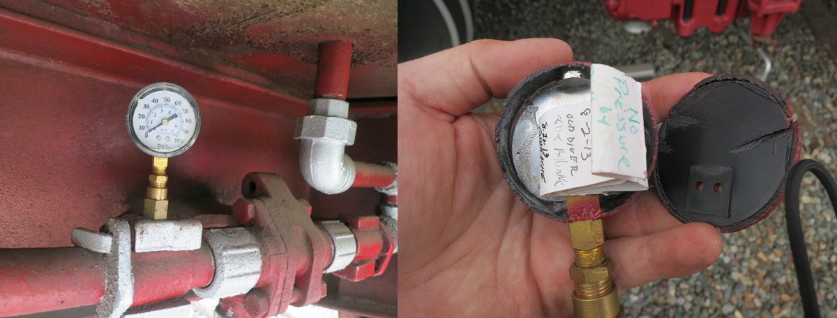
Lets kick this off with a cleverly hidden pressure gauge that has been converted into a geocache.  The end of the pipe is magnetic, so it sticks to other metallic pipes in the area. There are only a few spots where such a hide works, but in this case it was very effective.

The cache description said "Beware killer crocs spotted in the area". The humour alone makes this cache favourite point worthy.
Sometimes it is the simple hides that work best. This hollowed out stump fit in perfectly with its surroundings.  You cannot tell from the photo, but all of the trees in this area look pretty much the same.  The brass pipe helped keep it all together.  This is one of the better hides of this type I have found.
Another classic is the cache suspended in a tree.  One has to lower down the cache using a rope and pulley system of some kind.  This was a simple suspension, but the container was very thematic, don't you think?

If you can't make it out, this is a toy space ship, ALF themed.  Another example how a little bit of humour, and in this case a nostalgic cultural reference, adds a lot of character to a geocache, and allows it to stand out from the crowd.
Another take on a classic hide.  A muggle would likely never notice this, but a cacher can pick it out fairly easily.  It helps that the camouflage was taken (at least appears to have been taken) from the same wood that the rest of this retaining wall is made out of.  Makes it match perfectly.  The only clue is the slight offset bit of wood.  


You can check out the rest of the posts in this series by clicking here: Creative Cache Containers: The Series.

Go forth and create. Make the geocaching world a more interesting place.

Have you found any creative caches?  Drop them in the comments below.

Monday, March 24, 2014

Childhood Wisdom

So be sure when you step.  Step with care and great tact
and remember that life's a great balancing act.
Just never forget to be dexterous and deft.
And never mix up your right foot with your left.
- Dr. Seuss

Sunday, March 23, 2014

Garmin Monterra Review Part 6: Conclusions


To wrap this review up, lets summarize some of the strengths and weaknesses of the Garmin Monterra.

Strengths
  • Relatively new Android OS
  • Android side of things works great
  • Workable display
  • Power pack should save a lot of money on batteries
  • GPS and GLONASS provide excellent accuracy
  • Comes with international power adaptors and screen protectors
  • Supports a virtual unlimited number of caches
Weaknesses
  • Still have to reboot device for Garmin apps to see new maps and GPX files
  • Large physical size
  • Burns through power like a congressman burns through cash.
  • Some subtle yet incredibly annoying UI apps on the Garmin legacy side.
  • Expensive
Conclusion

Going into this review, and given the revolutionary aspects of the Monterra, I expected this device to be weak in some areas, and stronger in others.  What I didn't expect is that these areas were completely opposite.  The Android side turned out to be stellar, and the legacy Garmin side turned out to disappoint.

Despite how shiny and new this device is, and how convenient the Android OS makes the device to use, its downsides far outweighs its upsides.

At one stage during testing I had the Monterra, the Montana, and the eTrex, all ready to go in my pack, and honestly, every time I reached for a GPSr to search for a cache, my instinct was to pick the eTrex.

The Monterra is pretty, but I'd rather keep my current setup, all things considered.


Did I miss anything you wanted to see in the review? Drop me a line in the comments and I'll address it inline, or in a follow up post.

<<  Previous section: Power    |    Wrap around to the Introduction ^^

Garmin Monterra Review Part 5: Power

We come at last to the issue of power.  Battery life is one of the most important issues that a geocacher faces when going out in the field.

This is where the Monterra falls flat on its face.

I canna do it, Captain!

I have yet to see a GPSr from Garmin that will not last at least a full days usage in the field.  I have geocached for 12 hours straight with my Montana 600, a device which uses the same size power pack as the Monterra, with power at the end of the day to spare.

The Monterra gets nothing close to this.  The first time I took out the Monterra on a caching run I got just under five hours from it.  Five.  Take a moment to ponder that. This isn't barely a solid mornings worth of caching, let alone an entire day.  In Garmins defence, I did take the device straight from the charger, and did not do any of the normal power saving things one can do on such devices, like lower the display brightness, or turn off the radios.

I decided to give it a second, more fair, attempt, and gave it every chance I could:  Full charge overnight.  Turned off all radios except the GPSr, turned the backlight down to 0%. I shut down all Android apps, and only used the ones provided by Garmin.

I turned the GPSr on in the park I was caching in for the day, and cached for 3 hours, 25 minutes.  I found 12 caches.  When I was done the battery was at 45%.  To compare this to a device I know has great battery life, I brought along my Montana and let it run the entire time I was caching, with as equal usage as I could give it.  It was at 85% battery life by the end.

I hope you can see the problem here.

One handy feature of Android devices is that they give pretty decent stats about where the power goes.  As you can see it went mostly (64%) to Garmin Outdoor Apps. Luckily this looks like a software problem and could theoretically be fixed in an update.  However until then, stock up on batteries.  It takes 3 AAs each, and if they last the same length of time as they did in my Montana, you'll get about 3 hours from the set (I typically got 2/3rds of a runtime from AAs on the Montana as I did from the battery pack)

Charging Time

Garmin seems to also have issues with charging. For some reason the Monterra just burns power.  It can take 4-5 hours to get fully charged from the provided wall plug.  In contrast my smart phone takes about 2 hours.

The Monterra seems to have trouble getting charged from a computers USB port while its turned on. My phone charges just fine, albeit twice a slow.  I think Garmin needs to rework their power systems.

Note: I feel comparing the charge times between the Monterra and a Nexus 4 is a fair comparison. Both have roughly the same size batteries, do roughly the same things on the same general OS, and both charge via USB. If anything the smart phone should fair worse as it has a larger battery to charge, more radios, larger display, and faster processor, all of which should burn more energy.

Hopefully these power issues are a software issue and can be fixed in the future.  As it stands now the Monterra falls well short of acceptable power usage for the hard core geocacher.

<<  Previous section: Legacy Garmin Software    |    Next section: Conclusion >>

Garmin Monterra Review Part 4: Garmin Legacy Software

Let me start off by saying that, in general, I have been quite pleased with the software that Garmin puts on their GPSr devices.  I have very few complaints with how my personal GPSr devices work, and all of them are minor.

Going into this review of the Monterra I suspected that the Garmin side of things would remain as useful as it always has.  There did turn out to be a few problems.

UI Issues And Schisms

I ran into some serious user interface issues that nearly caused me to pull my hair out, for it is amazingly annoying.  The issue comes down to changes in how the geocache dashboard works.

On other Garmin GPSrs that I have used (namely the Montana 600) during navigation to a geocache I am presented with a map. On top of that map is a dashboard that has basic information: cache name, direction, distance etc.  When one touches the dashboard one is presented with details about that cache. Simple interface, and exactly the result I expect.

On the Monterra the navigation is, essentially, the same setup. Map screen with a dashboard on the top showing cache name, direction and distance.  However when one touches the dashboard one gets presented with a list of caches, sorted by distance.  This means that I have to then select the cache I want again before I can view its details. I already selected it once, which is the reason why the dashboard is navigating to it, so this extra step really grinds my gears.  It is made doubly annoying if the cache is not the closest cache as one has to scroll the list to find the cache first, they touch the entry to get the details.  Every time this happens I keep mentally screaming "Just show me the bloody cache!"

Update(2014-03-29): Apparently the above issue has been fixed in the latest Garmin Outdoor Apps update, 1.18.  Click here to get details on updating.  This does bring up a question tho:  Why the crazy update scheme, Garmin?  In a world that already has an app store, why force users to side-load your APK?

There is a third annoyance in that selecting caches from the list seems to require an extra hard touch, which doesn't happen at any other time.  Not sure if the Garmin engineers intended this bizarre behaviour, but its definitely a bug, and an annoying one at that.  This all may seem minor, but since selecting caches and viewing their descriptions is 50% of what I do with a GPSr, this is a serious black eye on the device.

Legacy Vs New

Another issue is more a result of the cross between the way Garmin traditionally loads data onto the device and the new modern world.

In an Android world, if an app wants to use a compass, it can provide its own, or use a signal called an intent to prompt the use of any other compass or compass like apps that may be installed on the device. This way a user can pick and choose which compass or map they prefer, and use it for most things.

I sort of expected this same function sharing from Garmins software as well. However I could not find a way for Android geocaching apps to be able to share Maps or cache listings.  I am not sure if this is a true limitation of Garmins software, or simply that the Android apps are not set up to share such data, but if any Garmin engineers read this: Making your compass and maps apps shared via an intent would be awesome.

This also means that if one wants custom maps one has to load them multiple times. Once for the Garmin side, and another for whatever Android device is being used.  This rapidly takes up space. Hardly ideal.

Data Loading

Loading data (GPX or custom map data) is also different, but not necessarily in a bad way, and it is Androids fault.  When plugged into a computer via USB, most other modern Garmin GPSrs mount their drives as USB drives, and data can simply be copied back and forth as it can on any other drive on the computer.  Since Android does not allow its drives to be mounted in this way, one has the additional step of having to install an app called Android File Transfer to copy data directly to/from the GPSr. Android File Transfer is free, and available here.  Use of Android File Transfer is standard fair for Android, so it shouldn't really come as a surprise, except that it now applies to your GPSr as well.

Of course one can simply use a program like Dropbox to copy data onto the device.  The Monterra still expects the data used by its apps to be under the /Garmin directory so one can simply save GPX or map files there and the GPSr will make use of them.  Bizarrely tho, it still requires the device be rebooted before the Garmin apps will see the new data.

Garmin Desktop Apps

Both MapInstall and BaseCamp seemed to work with the Monterra. I actually used MapInstall to put a set of OpenStreetMaps onto the device for testing purposes.  The one catch I had was that Android File Transfer started up as soon as I plugged in the Monterra to my computer, which caused the Garmin apps to not see the device.  The solution is to simply close Android File Transfer before using the Garmin apps, but it is one more thing that gets in the way, and may not be intuitive for the new user.  These problems were seen on an iMac, so Windows users may get different results.  Just something to watch out for.
<<  Previous section: Android    |    Next section: Power >>

Garmin Monterra Review Part 3: Android

So far this has been a typical Garmin GPS.  So lets get down to why it is special: Android.

I know many geocachers have had reservations about such a GPSr/android device.  The two biggest concerns are about being stuck on an old version of Android so their apps will not work, and the other being that the screen is not large enough.

Lets address these issues head on.

Android

The version of Android on the device is Ice Cream Sandwich (4.04).  While not the newest version (which is 4.4 Kit Kat), it is still quite modern.

Using Android on the Monterra feels just like getting any new Android device.  I was first prompted for my Google account information, and asked to set up the wifi connection.  It then logged me in to a fully functioning Android experience.  I even started getting new email notifications right away (an unexpected and surreal experience to do a Hangout on a GPSr).

I promptly started installing my favourite geocaching apps: CacheSense, Locus Pro, GCC, Groundspeak's Geocaching App etc.  All of them worked flawlessly.  There were a few minor issues with performance, for example Locus Pro took twice a long (60 seconds instead of 30 seconds) to process a 1000 cache GPX file, but in general the performance was not an issue.

You have full access to the Google Play Store, and the Monterra shows up as a device on the store so you can simply push apps to the device from the website.  Rather handy.

If you don't have any apps you want to use, the device does come preloaded with some apps.  All of the typical Garmin functionality is implemented as Android apps pre-installed on the device, for example.  The Settings app looks like typical Android as well, aside from a few additional menu options to configure features not normally found on phones (such as turning on WAAS, or selecting GPS/GLONASS options).

In fact Android works so well on the device I forgot I was using a GSPr at all. Except for the display and larger physical size, it felt like I was using my smart phone.

This conveniently segues us to the display, so lets tackle that now.

Display

So the display resolution is rather paltry sounding.  At 272x480 pixels it pales in comparison to the typical modern Android device. For example my Nexus 4 has a resolution of 1280x768.  So one would be understandably skeptical about how useful Android is on such a low-res screen.  One would, however, be completely wrong.

Now I am not going to sit here and tell you that the screen is amazing in all respects.  I would never want to watch a movie on it, for example.  However it is quite adequate for its needs.

I took side-by-side screen shots of Locus Pro so you can compare the difference between a modern smart phone display and the Monterra:

As you can see, the screen is quite adequate for all of its limitations. The Monterra is not as crisp as the Nexus 4, but most folks would not have any issues using those maps.

Some of the menus and buttons end up in different spots on the screen, but with a very small amount of exploration I had no problems getting used to how my favourite apps worked on the Monterra.

The display also looks great in the sun, and I had no problems reading it, even in direct sunlight, and with the backlight turned completely off.

I was completely blown away by how polished and usable the Android experience is on this device. I was about to declare the Monterra one of the best GPSr's I have ever used.  I was ready to toss away my old setup of using an eTrex 30 and a Nexus 7.  That would prove to be a premature conclusion however, as there are some critical problems with the device, and they are where I least expected them.

<<  Previous section: Technical Specs    |    Next section: Legacy Garmin Software >>

Garmin Monterra Review Part 2: Technical Specs

Whats In The Box?

The Garmin Monterra comes with the following things:
  • GPS unit
  • Manuals
  • USB power supply
  • USB cable
  • Lithium-ion battery pack
  • International power adaptors
  • Screen protectors
It is a list comprised of exactly what you would expect, except the screen protectors are a nice touch.   It would have been nice if they had included some sort of strap, however.  The first thing I did when I pulled the unit out of the box is attach a small lanyard for carrying purposes.

Technical Specs

The full list of technical specifications are on the Garmin website (listed here) so I won't bother repeating all of the specs here, but I will list the salient details for convenience:
Size difference compared to a standard
pack of playing cards.
  • 4" touchscreen,  272x480 pixel resolution
  • Weight: up to 13.2oz depending on batteries used.
  • Power: 3AAs, or the 2000mAh lithium-ion battery pack
  • Supports custom maps
  • 6GB memory with the base maps, 3GB with topo maps.  
  • microSD card for additional map storage. (microSD card not included)
  • Can hold an unlimited (where unlimited is the limitations of the devices memory) amount of caches.
  • 8 megapixel camera.
  • Wifi enabled.
  • GPS and GLONAS enabled.
It is important to note that this device is huge for a GPSr. It is the largest handheld GPSr I have ever seen.  I added a size comparison photo to a deck of cards to get an idea of how big it is.  I still find, however, that it would get lost in a pack or pocket, so it is definitely manageable.

Touchscreen

The touchscreen is resistive, which means it works in the rain, and with gloves on.  For the most part the screen is quite responsive. There are some exceptions, for example the Geocache List window requires an extra hard press to get it to recognize a touch.  I have no idea why this is as other touches to the same part of the screen in other modes have no issues. 

In general if you have used any Garmin touchscreens, this one acts exactly the same.  

Camera

This seems as good a time as any to discuss the camera.  It is an 8MP camera, which is quite decent.  It does  not have any optical zoom, so its all digital, which vastly reduces quality when zoomed.  If you look at the camera as being a typical smart phone camera you have the right idea.  It is great for taking those quick in-the-field-memory shots, or photos of information for multi-caches or virtuals.  However if you don't consider your smart phone camera to be sufficient for your photography needs, you will find the same here.  Photographers will still need to being a proper camera into the field to get awesome shots. However, as I mentioned, it is more than adequate for those impromptu photos.

Accuracy

In comparisons with my other GPSrs (Garmin eTrex 30, Garmin Montana 600) I didn't really find any differences in GPSr accuracy.  This shouldn't be surprising since I haven't seen significant changes to this in quite some time. The GLONASS support will help in the future when the Russians fly some more satellites, so things will hopefully get better than they are now.  However now is looking pretty good as it is.

<<  Previous section: Introduction    |    Next section: Android >>


Garmin Monterra Review Part 1: Introduction

There is literally nothing more fundamental to geocaching than a GPS receiver.  There is also few things as much fun as exploring new tech, and the Garmin Monterra promises to be a revolutionary step in the development of GPSr units for the geocacher. As you can imagine that when I was offered the chance to review the Garmin Monterra GPS first hand, I jumped at it.

The following is my review.

Before we continue...

Now, a couple notes before I get into the meat of things.  Blogger, the system this site uses, works awesome for the smaller posts that I normally do, but it is not so awesome for longer ones.  As a result I am going to put my review in a series of posts released all at once, and linked all together.  Hopefully this will end up feeling like a unified review.

Second note:  I have never done a product review before, so its likely I may have missed something.  Please feel free to drop missing bits in the comments and I will do my best to get them addressed.

Note The Third:  I am an avid geocacher, and this review is geocaching specific.  This unit could be used for a great many other things, but those use cases will remain theoretical.  I am also assuming my readers are geocachers.  If you are not a geocacher and something isn't clear as a result, please feel free to drop a comment and I'll clarify things for you.

Fourth Note:  I am using a Garmin Montana as a comparison device to the Monterra in a couple areas.  The reason is two fold:  I've used the Montana to find over 1200 geocaches and am very familiar with how it functions in the field.  It is also a very recent model so there is not a lot (in theory at least) changes in the hardware.  I also compare it to the Garmin eTrex 30 as it is my primary caching device.

Whats the big deal anyway?

First question has got to be: why do we care?  What is the big deal about the Monterra anyway?  The Monterra is the first GPSr from Garmin (perhaps from anyone) that is based on Android.   Many geocachers have stated that the one thing they wanted in geocaching technology is the ruggedness and battery usage of a stand alone GPSr merged with the flexibility and functionality of a smart phone.  The Monterra promises this exact holy grail combination to a geocacher.

This device is expensive, at $650 USD for the base model ($700 with topo maps), so it has big shoes to fill.

The burning question is: does it live up to its promise?

You can find the rest of the review on these posts:
So on to the next section: Technical Specs >>

Saturday, March 22, 2014

Indiana Jones And The Cache Crusade

I really felt the need to get out of the house today and hit some trails.  So I headed an 75 minutes south west to the Latta Plantation.  Latta Plantation is a large nature reserve full of trails, horses, muggles, and geocaches.

Not one to simply find a geocache, I wanted to epic things up and go on a grand adventure,  so I brought along the most famous of all adventurers: Indiana Jones.

If you are going to roll with someone, you might as well roll with the best.  Its how I roll, at least this time.


Together we found a bunch of caches.  We join the action after we found our first cache.  We had to locate the treasure in the next cache, but where was it?  What stands in the way?  What will we find inside?  Will there be snakes?  Who keeps asking these questions anyway? Oh, I do.  Sorry, I'll stop.

Lets watch the master at work.  After checking out the signs the locals left, long ago, and translating their ancient runes, Indy sought high ground to get the lay of the land.   Putting all the information together he quickly determined which direction to head. GZ is over there!
The epic jungle holds many dangers, and the bushwhack to Ground Zero was a hellish nightmare of giant leaves, and playful squirrels.  Not to mention snakes (why does it have to be snakes?!?). 

Eventually our plucky hero breaks into a clearing and spots something in the distance.

With reckless abandon, he rushes in for a closer look. Is this the cache he seeks? Could this be the location he's been searching for ever since the last cache 7 whole minutes ago?  Will victory finally be in his grasp?  Will the story of this adventure finally allow him to score with Babs, the perky first-aid nurse at the university where he has his day job?
Yes, indeed it is, on all counts (hello nurse!).  One more victory for Indy in the books. Let's sign the log and get it back to the museum... Babs awaits... rowr.


The End.

So, that was just a little taste of adventuring with Indy.  He could be back for more, or he could spend the rest of his days teaching archeology at the universty.

What do you guys think? Do you want him to come back for a sequel?

Wednesday, March 19, 2014

Seeking International Geocachers for Travel Bug Race

In 2013 I held a world wide travel bug race. Details here: http://debaere.blogspot.com/p/take-me-to-your-leader.html. A lot of folks enjoyed following in, and participating in, the race so I want to do it again.

This year I am going to repeat that race, but on a larger scale.  However I will need some help to get the travel bugs released globally.  If you are interested in helping, this form is for you.

This is a sign up form to release a travel bug for the 2014 Travel Bug race.  I am particularly interested in geocachers in the following areas:
Eastern Canada
Southern Europe
South America
Africa
Asia
New Zealand.

However I will accept offers from anywhere.

If you live in these areas and are willing to release a travel bug for the race, please fill out the form (linked below).  I will then contact the most likely candidates and mail out a travel bug.  I am going to select folks based on geographic diversity, so please don't be upset if you are not selected.  I thank you in advance for your interest.

By filling out this form you are agreeing to allow me to mail you a travel bug, and that you will release it in a suitable cache as soon as possible, preferably within 2-3 days of receiving the travel bug in the mail. I will provide the travel bug, and pay for all shipping and materials.  You just need to drop the bug in a cache.  Pretty easy.  Your reward is to be part of something epic.

Note: I will keep all of your information private. The only information I will release is your geocaching name, and the location where the TB was dropped (which will be listed on the TB pages on geocaching.com anyway).  All your personal information will be deleted once the TB in question has been dropped in a cache.  Trust me, I'm Canadian.

[[ SIGNUP IS CLOSED - STAY TUNED FOR MORE DETAILS ]]

Wordless Wednesday


Monday, March 17, 2014

The Wizards Box

My latest cache is made from recycled materials.

Last year a tree fell in my backyard.  (I was there to see it, and it didn't make a sound).  Contained on said tree was a bird house (the prettiest birdhouse that you ever did see).   The house got damaged a bit during the felling, and I didn't have a place to put it back up, so it sat in my basement, mocking me.

I decided to make a geocache out of it.

It has become my latest cache creation.  I call it The Wizards Box.  It is a bit of a gadget cache in that you need to do some "magic" to retrieve the container with the log book.

Inside is a PVC pipe, and in the bottom of that pipe is a bison tube with some metal bits JB Welded onto it.  Unless one has extraordinarily long fingers one cannot reach the logbook.

The perch has a rare-earth magnet on the end.  One needs to extract the perch, and use the magnet to fish out the container from the hole.  Once that is accomplished it is a simple matter to open the bison tube and sign the log.


This is my first in-field puzzle cache that I have put together.  The cache description is here: The Wizards Box.  What do you think of it?  Let me know in the comments below.

Sunday, March 16, 2014

2014 New Year, New Hunt Photography Scavenger Hunt

The following are my submissions for the Autumn 2013 edition of the +Chrysta Rae's Photography Scavenger Hunt.

The hunt works like this, We are given 10 categories, and 2 months to shoot them in. At the end everyones photos are revealed, and the winners announced. 500 of the finest photographers compete in the hunt so competition is fierce. You can see my previous hunts here.

Sharp eyed readers may note that there are not 10 photos here.  This is because I only had the time and energy to get some of them done.  It is a lot of work getting Lego minifigs to come out this way, especially when all I have for a camera is a Canon S100 point and shoot with limited focus.  Still, I got a lot of laughs from my shots, and people seemed to enjoy them, so I am grateful that my work is appreciated.

So, onto the photos!

Category: Healthy: (all submissions)  I received an honorable mention for this photo.

The inspiration is obviously Sweating To The Oldies.

Category: Hungover (all submissions)

Indiana Jones gets into all sorts of mischief, doesn't he?

Category: Embrace (all submissions)

It is almost impossible to get Lego minifigs in a hug, so I went with the obvious pun.

Category: Careless (all submissions)

Oops.

Category: Circle (SOOC) (all submissions)

This category was designated "Straight Out Of Camera", which means, aside from cropping, no Photoshopping of the photo is allowed.  However nothing said no photoshopping of the props.  I took a screen shot of one of my G+ circles pages, then 'shopped in various photos of Stormtrooper minifigs.  I then displayed that on a Nexus 7 tablet, arranged the two minifigs on the end, and the results are what you see here.

Category: Fuschia (all submissions)

I am a man, which means I only know the following colours: red green orange yellow blue, black, white, brown.  Everything else I add an -eenie or an i-sh: "It's greenie blueish".

Once again I went with the obvious pun:


(I still have no idea what colour fuschia is.)

So what do you think?  How can I improve my work?  Let me know in the comments below.

Saturday, March 15, 2014

Murray's Mill CITO

For a geocacher the world is our playground. Sometimes its nice to give back and clean things up a bit. Today the kids and I did just that.

We attended a Cache In Trash Out event at Murray's Mill (if the location sounds familiar, it is likely due to my post about a month ago.)

We, and 7 or so other cachers, walked the 1.4 miles of trail (one way), picking up garbage as we went.

Since I had the kids with me, and I was playing the role of a single parent, I spent more time on kid patrol than garbage patrol, but I managed to help out a bit.  I also took on the role of group photographer.  The following series of images documents the morning.

The runs along Murray's Mill pond.  The first section also runs alongside a picturesque farmers field.
After the field, the rest of the trail is in the woods.  There are also some bridges to help hikers over the boggier bits. The kids took some time out to check out the (really small) creek.
For the most part the group stayed together in the quest to rid the trail of trash and litter. This next shot was taken at the far end of the trail.
On the way back the kids took some time to kick some dirt, cause: kids.
The trash was rather heavy by the end, so FailedApparatus and nyhof rigged up an old-fashioned carrying system.
Since everyone else had something to carry, Abigail picked up some corn cobs from the field.
The view of the mill (on the left) from the back side looked really good on this (almost) spring day.
There are a few old buildings across the pond from the mill (not pictured: the nearby geocache).
After a picnic lunch (PBJ baby!) we headed out to explore the mill.  See some water falls, and get into general hi-jinx.  The kids started climbing over rocks. Abigail actually did pretty good following her big brother has he monkeyed over the rocks like an old pro.
After the rocks were used up we piled into the Geovan of Destiny and headed on back home.  Both kids were asleep in the first 10 miles (turns out walking 2.8 miles, plus a good rock climb, is rather tiring for the toddler set).  The drive home is 45 minutes, but I ended up taking a munch longer drive so then kids could get a longer nap in - 1.5 hours in total.

This was a good day.  Both kids had lots of fun, as did I.  To top it off we left the world a little better off than we found it.  Not bad for a morning spent in the geocachers playground.

Thursday, March 13, 2014

Esse Quam Videri From Space!

While doing planning for a cache run in Raleigh NC I ran across this little gem in Google Earth. 

This lives at the North Carolina Art Museum, which is rapidly becoming one of my favourite places to hang out (it is the place that also contains the life sized Camera Obscura).

This is art that was not even possible 150 years ago... it was made specifically to be viewed from aerial photography.  Each letter is unique.  In short, its awesome and superb, and its mere existence makes me happy.

Sharp eyed folks may notice that the "I" in "this" has words written on it. They are the North Carolina state motto "To be, rather than to seem", which is translated from the latin "esse quam videri" and means "Few are those who wish to be endowed with virtue rather than to seem so.", or in other words "there are many folks who want to be known as good, but only a few who want to be good".  (note: at this stage I wish NC picked a cooler motto, but "live free or die" is already taken).

I headed over to the NC Art Museum and checked out the art from ground level.  This is the view from 0ft relative elevation:


As you can see, it is much more impressive from the air. If you know what you are looking for you can make out the letters, but if you were just a random passer-by, you'd never know you were walking through this aerial piece of artwork:

Cool, eh? Check out the art work for yourself by clicking on ye olde Google Maps link here.


Have you seen similar bits of aerial artwork in your travels?  Let me know about them in the comments!

Monday, March 10, 2014

Oh Crikey, It's The Rozzers!

So this scenario happened to me the other day:

(Long story short, my name is on the log sheet, and I didn't get stopped for questioning. Ain't geocaching grand?)

Sunday, March 09, 2014

Skirt Lifting

You never know what you'll find when you go skirt lifting*. 

*No, not any skirt - just the one at ground zero (unless you buy it dinner first).

Tuesday, March 04, 2014

Mega Events: A Survival Guide

Geocaching Mega events are large, complex things. Often there are thousands of attendees, and multiple activities and/or locations.  This can be quite daunting to a new cacher.  The following are some tips for getting the most out of your Mega event experience.

95% of complaints I have heard from first time Mega event participants would have been solved if they took some of the following advice to heart.  Hopefully this post will help future first time  Mega event attendees get the most out of their experiences.

Be An Active Participant
The best advice I can give for the first time Mega attendee is to be an active participant.  Don't expect hand-holding, or that someone will actively show you exactly what to do or where to go. Mega events are way to busy, and the volunteers do not have enough time to personally greet everyone (as much as they would like too).  Take it upon yourself to get informed of the various things going on during the event and plan your time accordingly.  If you are not sure what is going on, ask someone.  Events typically have an information booth manned with volunteers with all the information you may need.

Be Informed
Mega Events are often large and complex, and it  can be very easy to get "lost in the crowd".  They often have themes and “personalities”.  Some Mega events are basically gigantic get togethers, others have themes (like earth caches, historical events, or holidays such as ‘Halloween’), or are based around contests.   Depending on the theme, or even the location, your expectations and preparations will be different.  Do your research ahead of time and come prepared.
Usually the schedule of events is posted to the event website well ahead of the event itself.  Sometimes it also includes a map of the event site.  I highly recommend attendees look over this information before arriving (or finding it out immediately upon arrival).  This gives you a chance to arrive on time, and plan your day so you can take in all the things that interest you.

Food and Parking
Also it is important to understand how parking/food will work ahead of time so you are prepared.  Some Megas are near urban centers and food and parking is plentiful and convenient, so lunch is just a quick trip to a local restaurant.  Others are in rural areas, far away from the closest restaurants..  Sometimes these events require meal tickets purchased in advance to get food on-site.   You are always welcome to bring your own food and drinks, of course.

I would always advise bringing snacks, and extra water. You never know when things go wrong, and it never hurts to be prepared.

Permission to Participate is Automatic
Activities at events are open to one and all, but its up to the individual to take the initiative to take part in them (something that can be difficult for the more introverted among us - myself included). It helps to remember that when you go to any geocaching event, you are among members of your own tribe.  You may not know anyone else, but you are already friends and have things in common (geocaching).  Once I clued into that, getting more out of the social aspects of geocaching events became a lot easier (something that does not come easy for someone as introverted as myself). It also made it easier to ask to join a group, if I needed to, to participate in an activity.

Be Flexible
Mega events are run by volunteers.  I have never seen event organizers give less than 100% of their time and energy into making an event perfect, but life always gets in the way, and sometimes things go wrong.   If something does go wrong, instead of complaining about it and letting it ruin your day, just roll with the punches.  It may also be a good time to pitch in and help out a fellow cacher in need.

Be Prepared
Mega events are about geocaching. So you should prepare for a day of Mega event fun the
same way you would prepare for a day of geocaching.  Make sure you have extra water and snacks in your pack.  Bring sun screen, bug spray, and a good hat.  Also bring extra batteries - maybe more than normal (a quick way to be someones hero at a geocaching event is to have a spare set of AAs to give to a cacher with a dead GPSr).

Look For Side Events
I have yet to attend just a Mega event.  Often the weekend of the Mega is full of other events, some related to the main event, and some are just hosted by random other cachers.  Look for these events to maximize your social time while at the event. These side events are also a great time to meet some of the local geocachers to get advice on the best caches in the area, or just to make new friends.

Book Hotels Early
Finally, book your hotel early.  Many Mega events are in areas that do not have a lot of accommodations close by. These locations tend to fill up quickly when a couple thousand cachers come to town. Book ahead of time.  You can always cancel a reservation if you end up not going.

Also the proximity of the hotel will affect your plans for the day of the event, so keep that in mind as well.

Have Fun
The whole point of geocaching is to get out and have fun.  Hopefully this post will let you come prepared to your next Mega event so you can stop worrying and love the adventure.

Got any more event survival tips?  Drop em in the comments.