Showing posts with label History. Show all posts

Tuesday, August 21, 2018

Building The Millennium Falcon: Canopies and Christenings

I have almost come to the end of my research into unearthed historical photos of the Millennium Falcon, original designation YT-1300 492727ZED from the Corellian Ship Yard archives.  This series includes all my results.

Visual records show that one of the last things to be installed onto the Falcon is the cockpit canopy. 
After the canopy was installed all that was left to do was some fine tuning of the computer system, a final update to the Dejarik table, and fueling up the engines.

As is traditional with ships, the final step before launch was the christening of the ship by breaking a bottle of the finest Corellian Ale over the bow by a dignitary of some renown.

In a weird quirk of fate it is unknown who the renown dignitary was, but it assumed she was a dilettante, and likely a mistress of the foreman as is the (just made up by me) Corellian tradition.
This is the last of the information I have been able to unearth about the Falcon's construction.  I have managed to piece together the majority of the story, but there are some loose threads.

For example, there is this weird note found at the bottom of the box of records that just had two faded words "Filming permit", and "Scene 7a - '/..kie.".    Weird, right?  If I figure out what that means I'll let you know.

Monday, August 20, 2018

Building The Millennium Falcon: Radar and The Cannon

I have been deep in research, plumbing the depths of the historical archives for photos from the Corellian Ship Yards - why?  Cause I'm a nerd that's why.

Historical photos of the Millennium Falcon, original designation YT-1300 492727ZED has been unearthed from the Corellian Ship Yard archives.  This series covers all of them.

Digging deep under piles of paper - what?  Paper in space? Yes.  Paper - under the pizza boxes, and receipts for Blockbuster rentals of the original trilogy, I found these images.

The first is installing of the main cannon.  Don't get cocky.
 The second is programming and aligning the radar dish on top of the falcon.
At first I wasn't sure why the radar dish would need to be aligned, as that is clearly a self-aligning model.  However digging under some old magazines revealed hand written instructions for getting free HBO.  Mystery solved.

Thats all I have this time.  I'm still digging thru the archives, so stay tuned for more historical photos of this legendary freighter.

Sunday, August 12, 2018

Building The Millennium Falcon: Outer Hull

Historical photos of the Millennium Falcon, original designation YT-1300 492727ZED has been unearthed from the Corellian Ship Yard archives.  This series covers all of them.

The outer hull of the Falcon is very rugged.  Over the course of many decades of adventures it has withstood a beating time and time again, but only came away with some carbon scoring.

Many of the hull panels were assembled off-site, transported to the construction site, and installed onto the main frame of the Falcon.  In this shot the top left mandible panels are being hoisted into place.

A workman cuts a bar of Durasteel to length.  Research has shown this panel is on the aft left side of the ship. right above the Dejarik board.

A small crew of workers install the louvers over the main engine vents on the right aft quarter of the ship. This painstaking process is hard to get right, but the attention to detail in installation is critical for the Falcon completing the Kessel Run in 12 parsecs.

Research into the history of the Falcon construction is still ongoing.  Stay tuned for more images as they are discovered.

Monday, March 23, 2015

The Arrow Points The Way

The last time I was in Las Vegas I took a day trip to check out some of the sights just a little beyond the glitz and glamour.

One of these trips brought me just over the state line to Utah - mainly because I have never been to Utah and I wanted to add it to my map. Besides it was only 2 hours away by car.

When I was there I ran into this obscure yet fascinating piece of aviation history.

The first regularly scheduled passenger flight in the US was made by Western Air Express on May 23, 1926.  It flew between Salt Lake City and Los Angeles California.  To aid in navigation, large concrete arrows were placed every 10 miles along the route.  One of these markers still exists in St. George Utah.

My wife helped point the way.  She also serves to show the size of the arrows - they should be quite visible from the air.
It only took 10 years or so before radio beacons replaced the need for these arrows.  However they remain a little known, but vitally important bit of American aviation history.

The arrow exists on top of a large hill, which provides some amazing views of the surrounding valleys.


How did I run across such obscure history on a random hill in Utah?  I was geocaching, of course. The cache was placed here to highlight the history, and to show off the beauty of this corner of the state of Utah.

As you can see, to retrieve the cache one had to get close to the edge of a cliffside.
A little bit of history, some amazing views, and a cache find.

Not bad for a morning spent in Utah, eh?

Thursday, November 06, 2014

Iter Avto: The Worlds First Car Nav Device?

While spelunking the interwebs last night I stumbled across this gem from history.

In 1930 a device was invented to help with car navigation.  Connected to the speedometer, it consisted of a paper map that scrolled at the same speed as the car.  In theory this would keep the map updated with the exact position of the car.

One of the major downsides to the device is that if the car turns, the driver (or his navigator) had to swap out to a different set of maps, and manually set them to the right spot on the map before setting off.

It also makes me wonder how far off the map gets if the car experiences wheel spin.

This clearly predates geocaching, which started in May 2000.  However it seems like the perfect creation for those letterboxers out there (a hobby which started in 1954.)

There isn't a lot of information on these devices on the Internet (it even lacks a wikipedia article), but these links will give you a bit more information (tho a Google search may also help):

Iter Avto - The world's first automobile navigation system (1930) [dieselpunks.org]

http://www.dailymail.co.uk/news/article-2147617/Iter-Avto-The-antique-route-The-sat-nav-1930-used-map-scroll.html [www.dailymail.co.uk]

Thursday, September 11, 2014

The GeoTrails Of Spartanburg South Carolina

Spartanburg South Carolina is home to several geotrails.  I figure it was about time I experienced some of them. Luckily I had a free day thanks to Labour Day.

So with this mission in mind, on Labour Day I left the house at the crack of dark and drove the 2 hours over to Spartanburg SC to see if I could put a dent into some of the geotrails in the area.

If you are not aware, a geotrail is basically a series of caches that revolve around a theme - normally features of an area - and as one finds caches one gathers information and records it into a passport.  When completed, the passport can be traded in for a geocoin.

I started my day doing the Hub City Spartanburg Geotrail.  This is a series of caches that takes one to various parks, walking trails, and cultural centers (art councils and community theaters), all clustered fairly closely around the city.  There are 25 caches on this geotrail, and one needs to complete at least 20 of them to qualify for a geocoin.  I ended up attempting all 25, however I DNFd one.

For this trail one had to collect a code hidden in the geocache and record it in the passport (which is, basically, just a paper with a grid of geocache listings on it).

Some of the geocaches were basic magnetic key holders, bison tubes, and lock'n'lock containers. However a couple were really cool containers like this one:
The majority of the caches along the Hub City Geotrail were in parks of some sort or another. Several were in a large green space in the middle of a city, which featured a series of trails running through some woodland, and along this really pretty lake.
The park also featured some sports fields, including this baseball park for Spartanburg High School (Go Vikings!)

Another cache was near an American Legion, which featured a really nicely done, and nicely placed, civil war monument.
At one of the artsy place (an artists maker space sort of thing I believe, tho don't quote me), a geocache was displayed along with the other sculptures.  So from now on, if anyone gives you grief about geocaching being a silly sport for geeks, you can show em this picture and respond with "It is not just geolocation of tupperware - it is an art unto itself!  You're welcome.
I finished the Hub City Geotrail around lunch time.  After lunch I started work on the Heritage Geotrail. This trail involved a lot more driving around. However it features a lot of places of historical significance to the local county, including this rather rustic looking cabin in the woods.
The Heritage Geotrail took me to a lot of historical signs (some easy to spot, some not so much).  I took some awesome shots of them, however they often contain information needed to complete the trail, so they are not shown to avoid spoilers.

However I also ran across this rather small, but old looking, post office.

I ran out of time before I could complete the Heritage Geotrail, but I got most of it done.  I'll just have to head back to Spartanburg someday to complete it, and tackle some more of the trails in the area.

The geotrails are really well done. I saw a lot of cool things, and learned some great history along the way.  It was a really fun and educational day of geocaching, and isn't that really what its all about?

If you are every in the Spartanburg area, and want to do some geocaching, you can't go wrong by doing one of these geotrails.

Have you completed a Geotrail in your area? Tell me about it in the comments below.

Wednesday, August 20, 2014

Osler Castle

One of the best things about geocaching is discovering things that I would never discover on my own. On my recent road trip thru central Ontario I struck geocaching gold. For deep in the woods by a pretty lake, way off the beaten track, lies the ruins of a castle.

The castle lies in the Blue Mountain region, right beside Collingwood, near Georgian Bay. Two interesting things of note:  I live near the Blue Ridge Mountains in North Carolina, so it was with some amusement that I ended up hiking in Blue mountains 800 miles away, and the range is part of the Niagara Escarpment - that sucker runs a *long* way.

To access the castle one needs to drive down a long dirt road and park at a trail head of the Bruce Trail, and hike 8/10ths of a mile through a nice set of woods.  The path is nice and wide, and the terrain pleasantly smooth.

Somewhere along the line you emerge from the woods into a small clearing.  It is at this point that you get your first look at the ruins of what was once an awesome looking castle.
Osler Castle was built in 1893 by a prominent lawyer from Toronto named Britton Bath Osler.  He built it for his sick wife Caroline, as it was believed the clean mountain air would be good for her illness.  Despite the cleaner air, she died 3 years later in 1896.  Osler himself died in 1901, at which time the castle was left empty and abandoned, set adrift to face the ravages of time. 

Over the intervening years, nature, vandals, and party goers took their toll on the castle, and it now sits in tattered ruins.


Just a few hundred feet farther down the path from the castle sits a rather picturesque lake.  I imagine the lake would have been visible from the windows in the castle back in the day.  Today its hidden from view by a very mature forest.
Today the property the castle sits on is owned by a development corporation who has designs to turn the area into a housing development.  However it is hoped the ruins can be preserved due to their historical significance.

I really hope this happens because Canada has enough condos and suburban development, and not nearly enough cool spots like this.
I like ruins.  Ruins are cool.

Thursday, August 14, 2014

A Road Trip in Central Ontario

A few days ago while I was back up in Canada visiting my in-laws, I went on a mini road trip to explore parts of central Ontario.  

This post covers the basics of that trip, and I will cover some significant sights I saw in more depth in follow up posts. 

I started my day by getting up at 5:30 AM, driving to Tim Hortons for breakfast, then getting some miles in.  I am based in Haldimand County, right along Lake Erie, so I had a couple hours drive ahead of me.

My first stop was at a virtual cache at a Korean War Memorial in Brampton.  There was a box of poppies there, so I stocked up for my own personal stash since they are hard to come by in the US where I now live.  

My next stop was in Newmarket Ontario, where I was born and raised for the first 6 years of my life( I quasi-covered that visit in the post Origin Stories). 

I then headed to a YMCA park on Lake Couchaching to visit an old limestone quarry. According to the earth cache at this location, the limestone from this quarry was extra pure and smooth, and was prized by lithographers world wide as excellent material for making printing plates.
While I was near Lake Couchaching I did a multi-cache on an elevated walkway that leads out over wetlands.
I then worked my way northward to Penetanguishene (heck of a town name, eh?) to do some more caching, and attend an event.  Hanging out with local cachers is always a treat, wherever I go.  Along the way I got this panoramic shot of the town from the highest park in the area.

The next day I headed west to the southern shoreline of Georgian Bay.  I started the day by doing a cache at the ruins of a castle (not something normally one can say in Canada - we're not really castle folk - that deserves its own post).  

I then checked out the Georgian Bay shoreline from an awesome park in Collingwood.  I brought my bike with me, and I took extra time to ride it up and down the excellent bike paths they have running along the shore.  They also have an inukshuk, which I am always a sucker for. This one was rather large and impressive.

From there I visited an earth cache at artesian well that boasts the cleanest water in the world (something to do with the unique ground formations causing extra awesome filtration).

I then did the second oldest active cache in Ontario, Bending Tree (another post coming).

Next up was a visit to an old church (covered up, assuming for its own protection), that was used by the first black settlers from the US, who came to Canada to avoid the slavery issues in the US.  Those black folk also helped defend us in the War of 1812 - just goes to show it pays to be nice to folks.
My next stop was at an old ghost town called Josephine (yet another post coming up!).

I finished my trip by doing an earth cache at The Devils Punchbowl in Hamilton Ontario, at which I captured this panoramic shot of the Hamilton skyline.
After that I headed back to my in-laws place.  It was a quick trip, but a fun one, and I ended up seeing a lot of history I didn't know existed - all in an area of the world that was essentially my backyard-at-large for the first 33 years of my life.

Stay tuned for more posts about the castle, ghost town, and second oldest cache in Ontario - coming soon to a blog near you.

Tuesday, July 22, 2014

Fort George

This year we found ourselves in Canada on Canada Day, so we celebrated with some friends by visiting the historical site known as Fort George.

For my non-Canadian readers, July 1st is Canada Day, which is a national holiday that commemorates the singing of the British North America Act in 1867 which united the three colonies and created Canada as a country.  Think of it as July 4th, but without the war.

Not that Canada's history is battle free. There were many battles and skirmishes during Canada's history before 1867. Many were between the colonies, but the most notable was with the United States during the war of 1812.

Fort George was one of the British forts used during the War of 1812.  It was captured by the US in 1813, and recaptured a few months later.

The fort is mainly made of earth works shored up with logs.

 The fort looks over the Niagara River, and is intended to make crossing the river as hard as possible.  This is a forward outpost used for monitoring the US side of the river.  There is a stone lined tunnel running from this post to the main fort.

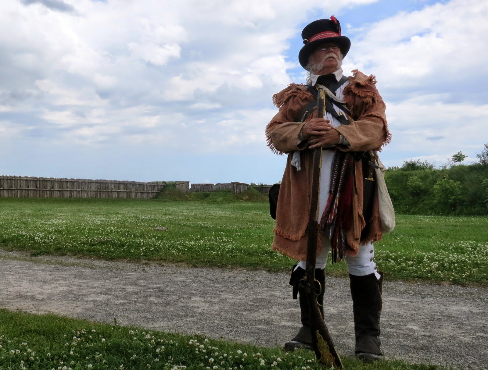
Most of the volunteers manning the fort today were in period dress. There were several demonstrations about life in the fort, from how they made food, to how they conducted warfare.
The musket demonstrations were the most dramatic.  A fellow dressed up as a British soldier and a fellow dressed up as a Militiaman gave demonstrations on how the soldiers handled their weapons. One thing I learned is that the purpose of the brightly coloured uniforms were to keep track of each other.  Black powder muskets produce a surprisingly large amount of smoke, so when a battalion of soldiers fire their guns all at once they quickly get lost in a fog of smoke.  In the style of warfare of the time keeping track of your own forces was a lot more valuable than hiding from the opposing forces.
Another thing I learned is that the British muskets were not rifled, whereas the Militia used mainly rifled muskets.  The Militiamen had a much more accurate shot, but the British depended on a wall of lead.  The defense of Canada was lead by the British, but they were vastly outnumbered, and would have completely failed if not for a large militia force, as well as a lot of assistance from the local native indians. 
As it stood, I don't believe too many battles occurred when the Canadian defenders were not dramatically outnumbered (tho it didn't stop us from ultimately repelling the invaders, and setting fire to the White House - which is why its white - you are welcome.)

A visit to an historic military base would not be complete without a formation of soldiers. Fortunately they had one of those too!
One of the activities was for us civilians to get a chance firing a black powder musket.  The musket was loaded by one of the volunteers, which was handed to me to shoot.  I did an historically accurate (in my opinion) commemorative dance, then took my shot.

Note that I was dressed in a Sergeants uniform.  I like to think I deserved the promotion, but in reality it was due to that being the only uniform that fit the larger sized gentleman.
I got to take two shots, which I took while picturing a line of damn dirty Yankees standing in front of me. (Don't worry, my American friends, I shook my fist at the damned British empirical menace 3 days later on July 4th to make up for it - fair is fair).  I am pretty sure I got the guy third from the left.
So that was my experience at Fort George.  I have always found the history around 1812 to be fascinating - one of my child hood heroes was Sir. Isaac Brock, the British general who defended Canada at the beginning of 1812, before being killed at the battle of Queenston Heights.

It is always a good idea to reach out and touch history. It reminds us of where we've come from, and how good we have it today.  Fort George was a great way to touch a part of my heritage.  Thus today was a good day.

Saturday, November 30, 2013

Oakwood Cemetery Of Raleigh North Carolina

Today I took a walk around Oakwood Cemetery in Raleigh NC, for contained within is 6 stages of a 7 stage multi-cache.

Oakwood is a fairly large cemetery as far as these things go.  It has residents dating back to the American civil war, and up to modern times - in fact there was a funeral held there today.

It is also the resting place of at least one North Carolina governor, and a Secretary of The Navy: Josephus Daniels (the cache page claims he switched the sailors rations from rum to coffee, thereby inventing the phrase "cup of joe."  Snopes says this is a myth which just goes to prove two things:  you can't believe everything you read on the Internet, and Snopes can be a killjoy).

While walking around I took some shots, starting with a lamb on a headstone:


The final is in a park a short ways away from the cemetery, but it now has my signature on the log.  A nice ending to a pleasant afternoons walk. through history.