

The unauthorized autobiography of a boy named Dave, filled with action, suspense, drama, humour (and yes, even sarcasm!), at a level so intense that only Googlebot cares.
Wednesday, September 30, 2015
Tuesday, September 29, 2015
The Nevada Desert
A month-ish ago I spent a day with the wonderful +Nancy Levan exploring parts of Nevada. We started the day doing a sunrise shoot over Lake Mead. Afterwards we went for a drive and explored some more of the desert.
We'll start with a shot from the northern-ish end of Lake Mead.


Everyone should spend time time in a desert. I'm glad I got this chance. Hopefully, someday, I will be back.
Sunday, September 27, 2015
The Hitman
This was my homework for an assignment from The Arcanum. What do you all think?

The assignment was to select, from the six provided, one image to process as I saw fit. I looked at the options and decided to combine two of them. The two photos was a head shot of a guy wearing red sun glasses, and an alley scene, both taken by +Scott Wyden Kivowitz. I added the dead body from a Google Image search, published under the Creative Commons (original here).
I also added the blood, a texture based on concrete, and some colour polarization on the glasses.
Thursday, September 24, 2015
A Sunrise Over Lake Mead

While I was there I met up with some of my friends from the Chrysta Rae Photography Scavenger Hunt, aka the Scavengers. One of those people was the great and wonderful Nancy Levan.
Nancy is a local, which meant she was armed with knowledge of good photography places, and had transportation. We headed over to Lake Mead to take in a sun rise.
We arrived just as the sky was lightening up, and we set about the business of setting up our cameras. This was my view.
Once again, stupid tourists and their cameras got in the way. This is what the camera saw from the front row.

One more, for the record.

Nancy, of course, also got in on the action.

One more shot of the brand new day, and we're off to explore more of the desert.

See ya next time!
Wednesday, September 23, 2015
Caldwell County Fair

It is officially fall. This means the leaves are starting to turn colours other than green, the days are getting shorter, the nights longer, the weather cooler, and various other autumnal things are autumnalling (as autumnal things do, and all according to plan).
It also means the county fair is in town (Carnie alert!)
On Tuesday we all headed over and check things out.
It is a typical small rural area affair - carnival folk selling carnival things, rides to be ridden, games to be gamed, various arts and crafts submitted for judgement to be observed, deep fried foods to be regurgitated, and something called 'funnel cake'.
The following are some of the sights and sounds (well, mainly sights, the sounds are mostly in your head), of the Caldwell County Fair.
We'll start with the centerpiece of the fair: ye olde yonder ferris wheel.


Another motion capture. This sucker really spun around.

It is getting dark, so this is the last shot of the evening.

The fair goes on until Saturday, so if you happen to be in the area, you can drop by and check things out for yourself. (if you are not, sucks to be you).
If you do go, try the funnel cake. I hear it's fun-nelly good!

Tuesday, September 22, 2015
Best Of Show

Today I took the family over (well, my wife drove, so technically she took us, but I was a willing co-conspirator and tag-alonger).
While there, we dropped by the judging barn to see how we did.
Turns out I got first place, and Best Of Show.
w00t.
So now I can add "award winning photographer" to my resume.
The picture is below.

Sunday, September 20, 2015
Photographing A Budding Cyclist
Being the proud father of a budding cyclist, and a dabbler in the Photonic Arts, sometimes means riding ones bike behind a 5 year old with a cell phone camera resting on ones handlebars.

Viaduct
On Friday my mission was thus: Drop the kids off at school at 8pm, drive up into the mountains for 75 minutes and drop my wifey off at a quilting retreat, then come back down the mountain to retrieve the various offspring from their various schooling places, starting at noon.
The mathematically inclined among you will note that this leaves about an hour of free time. I've always wanted to photograph the crown jewel of the Blue Ridge Parkway, the Linn Cove Viaduct, but never had the time. Since my path took me right across the Viaduct, I decided to spend my hour scouting out places to shoot the Viaduct from.
Spoiler: I found the spot.
This is me at the "overlook"

However if you keep walking passed the paved part, you get to the Tanawha Trail, which leads under and around to the other side of the Viaduct, 1300ft away. However that is where the good views of the Viaduct is located.
This is the view I had:
 That dang camera is in the way! (Stupid tourists.) So lets take a look at what the camera saw.

The mathematically inclined among you will note that this leaves about an hour of free time. I've always wanted to photograph the crown jewel of the Blue Ridge Parkway, the Linn Cove Viaduct, but never had the time. Since my path took me right across the Viaduct, I decided to spend my hour scouting out places to shoot the Viaduct from.
Spoiler: I found the spot.
This is me at the "overlook"

I put "overlook" in quotes as the location isn't so much a fenced off platform, or even a clearing. Its just a rock.
When one parks at the visitor center, one sees signs for an overlook, about 860ft down a nicely paved trail. However that ends at the base of one of the support colulmns, so its more of an underlook (not to mention there is so many trees in the way, you don't get much of a "look" either. In short, it's just full of lies.
However if you keep walking passed the paved part, you get to the Tanawha Trail, which leads under and around to the other side of the Viaduct, 1300ft away. However that is where the good views of the Viaduct is located.


Not bad.
I like this location. The trail was much longer and rougher than I expected (like stupid rough), and the light wasn't ideal, but I managed to get my shot, and that ain't nothing. It also took longer than I expected, but as it turns out, I arrived at my daughters pre-school with 3 whole minutes to spare!
I'll have to come back when the fall colours finish coming in, and the light is a little better. At least I know where I am going.
Friday, September 18, 2015
The Great Canadian Road Trip: The Sudden But Inevitable Conclusion
The Great Canadian Road Trip is rapidly coming to an end. In fact, after we finished exploring the real life fictional town of Dog River, and taking some shots of Saskatchewan At Night, we crossed the border into the US, thereby officially ending the Canadian part of the road trip.
If that seems sudden... thats because it is. Really once we crossed the border into North Dakota (at a town called Portal, which is likely the coolest name for a border crossing I have ever heard of - the cake is a lie), I sort of kinda forgot I had a camera or a blog, for 4 days.
 To distract you from this blatant and suspicious hole in the story, let me fill you in on some of the details.
We spent the first day driving across North Dakota. It is a nice state, but it didn't have what I want (which is, I expect, a common phrase that is the bane of the overworked and under-paid North Dakota Tourist Board).
The Day after that we drove to West Bend Wisconsin (along the way we said farewell to our plucky road trip conspirator, Liz).
In West Bend my charming wife and I spent a couple days attending the West Bend Cache Ba$h. Two days of geocaching and the ilk.
After that we took a ferry ride across Lake Michigan. It was actually surprisingly expensive to take this ferry across the lake - almost as much as the ferry to Newfoundland - but it had two benefits: We've never spent any time on the water on Lake Michigan, and we avoided driving thru the toll booth happy and traffic jam-y state of Illinois.
The ferry, being early in the morning, offered some nice sunrise shots.

Once we hit the Michigan side of the lake, we had breakfast with yet another Scavenger couple, the Schemeers. They turned out to be the last in a long line of Scavengers we met on this trip (total: 11)
We then proceeded to drive back to Ontario. (Wait! Isn't that back in Canada?!?) Oh look, a harbour!

Thus the cricle of road trip life was completed.
This was a heck of a trip. By far the farthest we've ever gone on a single trip. We put over 6000 miles on the round trip across Canada, and over 7400 miles from the time we left home to the time we arrived back. Along the way we added four new provinces and one new state to my geocaching map. I also went the farthest north I have ever been (Bon Accord), and the farthest west in Canada I have ever been (Golden BC).
All in all this is going down as one of the greatest adventures of our lives, and thats a pretty good way to spend a vacation, don'tcha think?
Wednesday, September 16, 2015
The Great Canadian Road Trip: Saskatchewan At Night
After we left Dog River, we were on our way back to Moose Jaw for the evening. As we drove the 37 klicks down Highway 39, we, the plucky group of photographers inhabiting the Geovan Of Destiny noticed the sky was a mix of happy sunset and ominous storm clouds. So, being a plucky group of photographers, we stopped for photos.
I have proof (in the form of +Liz Kaetterhenry taking a shot of some silos):

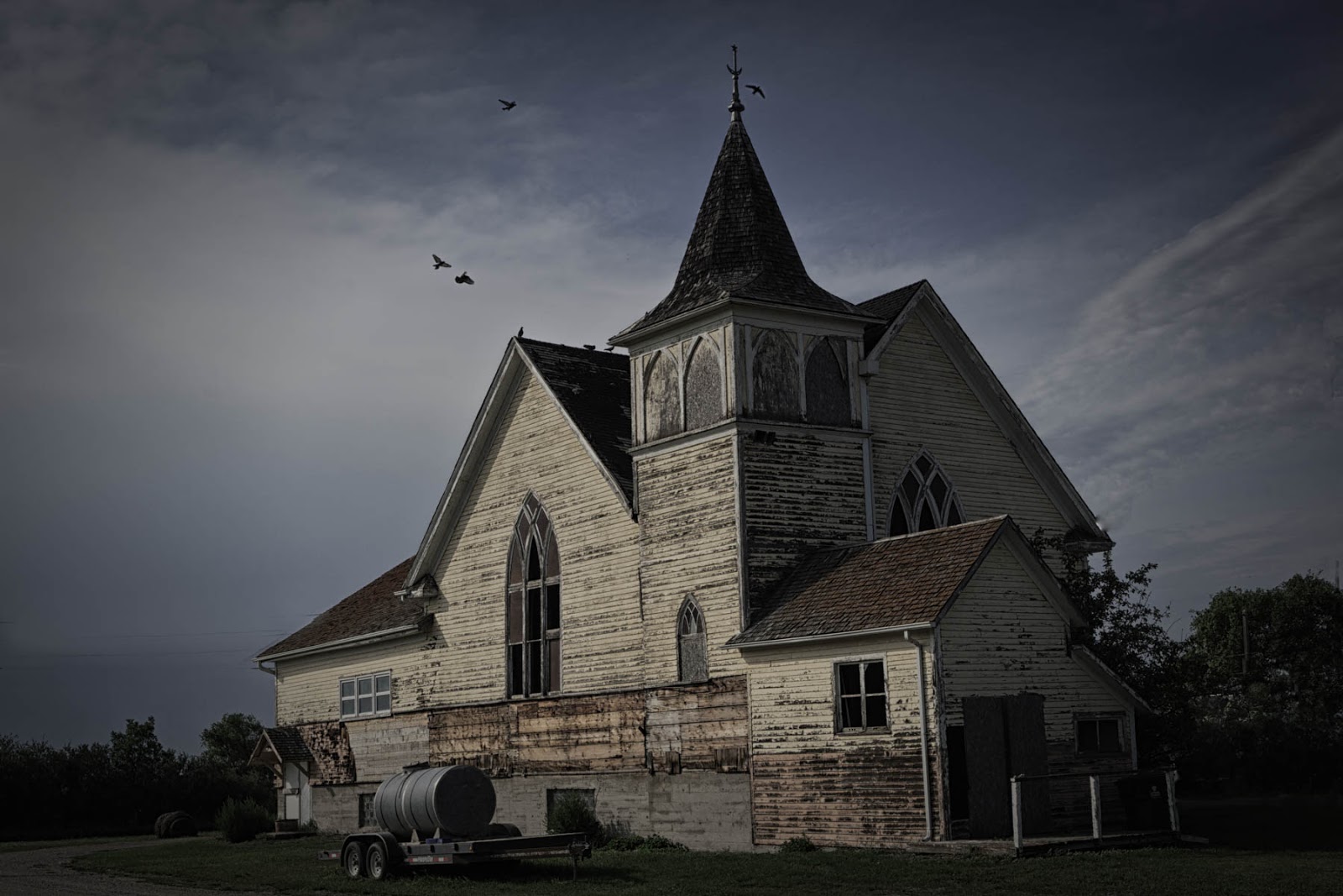
One of the cool things was this old church, just hanging out in a small town of Drinkwater (by small I mean 4 houses and a ruin).
 Aside from the church there was not much to shoot, except farm stuff (this is, after all, the middle of the prairies).
 I stopped at the side of the road in order to take this shot, simply because it was asserted that "there are not shots here." I think there is, what do you think?

Eventually we pulled over at a scene that obviously had some things to shoot. I shot this as HDR, which is why its not all blurry and noisy like the other shots in this post.
 As we were driving to Dog River, and then on the way back, Liz noticed these silos, and commented that they would make a nice photograph. On the way in we thought it would be too light out. On the way back we figured it would be too dark. After the success with the the above HDR shots, we decided it was likely still light enough to get a good shot, so we pulled a u-turn and headed back.
I think she was right about the silos (tho I was wrong about shooting this freehand)

I have proof (in the form of +Liz Kaetterhenry taking a shot of some silos):

One of the cool things was this old church, just hanging out in a small town of Drinkwater (by small I mean 4 houses and a ruin).


Eventually we pulled over at a scene that obviously had some things to shoot. I shot this as HDR, which is why its not all blurry and noisy like the other shots in this post.

I think she was right about the silos (tho I was wrong about shooting this freehand)

After the silo shoot we decided to call it a night. Our luck had held out so far - despite of the storm clouds looming we stayed quite dry. However as we headed off back to Moose Jaw the skies opened up and we practically rowed our way back to the hotel.
Still, a successful nighttime shoot was had by all.
Still, a successful nighttime shoot was had by all.

Tuesday, September 15, 2015
The Great Canadian Road Trip: Dog River
If you are Canadian you likely do not need to be told that Corner Gas is a hugely popular Canadian sitcom set in the fictional town of Dog River Saskatchewan.
Corner Gas remains one of my most favourite shows of all time, partly because it is full of pithy sarcastic humour, and an amazing amount of Canadian references and guest stars.
What you may not know is that the show was shot in a real life town called Rouleau SK. Many of the buildings, including the main set, exists as real places in that town.
This means, of course, that one can actually go and visit Dog River (squee!).
Checking out Dog River is literally one of the items on my non-actually-recorded anywhere figurative bucket list. So, naturally, I put "visting Dog River" at the very top of the "must see" places for our Great Canadian Road Trip. So come along with me and join in the adventure of the real life fictional town of Dog River.
Note: The rest of this post is all about Corner Gas the show, so if you are not familiar you may want to bone up on it before continuing (pro tip: many episodes exist on YouTube)
The show centers on the towns only gas station, Corner Gas, and the attached cafe, The Ruby. This building was built as a set for the show, but it still exists. It is the first thing one sees when entering Rouleau SK from the west.

A lot of the exterior details have been removed, but it is quite obvious that this is the real Corner Gas. My lovely wife, Debbie, is playing the part of Lacy, the owner of The Ruby (I suppose that makes me Brent, the gas station owner, in this little play.)

If you look to the left of the building you will see that the horizon is really flat. This is a running joke in the show. ("First you tell me that my dog ran away, then you tell me that it took three days.") The first thing that became quickly apparent - they ain't kidding about the flatness. I have never been to a place that was flatter than this part of Saskatchewan - the horizons were a *long* way away.
The Ruby is also home to a geocache, so of course I stopped to sign the log. I couldn't resist leaving my mark to say I visited The Ruby (I would have preferred that mark being the signature on the credit card slip when I paid for a meal served by Lacy, but alas my trip to the real life fictional world of Dog River has significant and annoying limitations - beggars can't be choosers).

One of the centerpieces of Dog River, like most small prairie towns, is the grain elevator. Normally the town's name is on the elevator, but in Rouleau's case they adopted the name that has made them famous, Dog River.
This shot was taken with the Corner Gas parking lot. I had to wait a good 15 minutes before the right truck drove by. It was worth it.
This shot was taken with the Corner Gas parking lot. I had to wait a good 15 minutes before the right truck drove by. It was worth it.

Once we finished checking out the set, we went exploring in the town (it didn't take long - it is a very very small town). There are geocaches on the grain elevator, the Surveillance Bush, the hockey rink (this *is* Canada after all), and in a random spot along a dirt road.
Fans of the show may recognize the place as the location where Oscar (Brent's bumbling father) found a pair of pants (Holy hell! A perfectly good pair of pants!"). (Remember that episode? It was a good episode. If you don't remember, go look it up, jackass! (just kidding, I didn't remember the location either)) If you really don't remember, I am standing in that spot (-ish) here signing a cache log.


These locations are, starting at the top left, The Howler (local newspaper), Hoff Insurance (insurance and liquor store - note that the business that actually owns that building also sells insurance *and* liqour... the meta-nature of this fact really butters my parsnips). The police station. The Dog River Hotel. Oscar and Emma's house, and an analog for Hank Yarbo's pick-up truck (yes I know his is blue, and this is red - no I don't care. I am sticking to it, I saw Hanks truck. Deal with it).
The Dog River Hotel is actually a bar and grill, and I believe the only place to buy food in town. In the show it is known as The Bar - nice to know it lives up to the name. I was forced by the rules of uber-fandom to delve as deeply as possible into this real life fictional world, which means I was required to grab supper at The Bar.
So we did.
I was all prepared to order a chili cheese dog (Brents favourite food), until my wife reminded me that I dislike chili, so I got the next best thing: bacon hot dog.
It was yummy.
Before we left Dog River, we filled up the Geovan of Destiny at the only gas station in town. By the rules of real life fictional locations, this is the proper analog for Corner Gas.

So I got gas at the original Dog River gas station... excellent! One more thing checked off my bucket list.
Everyone should come visit Dog River. Even if you are not a fan of the show (which you should become one. All the cool kids are. You wanna be cool right?), it is a nice picturesque town. It is also easy access - just an hour north of North Dakota - so (if my knowledge of US geography is as good as the average Americans knowledge of Canadian geography) my Yankee friends should be able to make it within a couple hours drive.
So that was Dog River. This is actually the last stop we made in Canada during our road trip. We did some night photography on the way back to the hotel, which I will cover in the next post, but after this we head back stateside for the remaining few days of the trip.
Stay tuned! It's getting dangerously close to conclusive now.
Monday, September 14, 2015
The Great Canadian Road Trip: Lake Louise

So, naturally, when we were planning our Great Canadian Road Trip we added a stop at the lake.
The lake was named The Lake Of The Fishes by the Stoney Nakota First Nations people back in the day. It is a brilliant turquoise lake surrounded by towering mountains.
The day we arrived happened to be a civic holiday weekend, so the place was absolutely packed with damned dirty tourists. So we had to wade thru crowds to get to the shore line. When we did, we got the amazing view that has made Lake Louise famous.

When we got there we were standing at the base of one of the mountains that line the lake. Some rock climbers were living up to their name.


That proved to be a wonderful end to a great day of exploring the Rockies.
We are finally heading back east, but there are a few more stops to be made, including a pilgrimage to the beloved fictional Canadian town of Dog River, Saskatchewan.
Stay tuned - it is going to be an action packed visit to a place where there is not a lot going on. Trust me.
Subscribe to:
Comments (Atom)